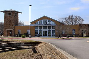
San Marcos station
(Redirected from San Marcos Station)
San Marcos, TX | |||||||||||||
|---|---|---|---|---|---|---|---|---|---|---|---|---|---|
 | |||||||||||||
| General information | |||||||||||||
| Location | 338 South Guadalupe Street San Marcos, Texas United States | ||||||||||||
| Coordinates | 29°52′37″N 97°56′26″W / 29.87685°N 97.94045°W | ||||||||||||
| Owned by | CARTS | ||||||||||||
| Line(s) | Union Pacific Railroad | ||||||||||||
| Platforms | 1 side platform | ||||||||||||
| Tracks | 1 | ||||||||||||
| Other information | |||||||||||||
| Station code | Amtrak: SMC | ||||||||||||
| History | |||||||||||||
| Opened | 2001 | ||||||||||||
| Passengers | |||||||||||||
| FY 2023 | 7,145[1] (Amtrak) | ||||||||||||
| Services | |||||||||||||
| |||||||||||||
| |||||||||||||
| |||||||||||||
San Marcos station is an intermodal transit center in San Marcos, Texas with primary ridership towards Dallas–Fort Worth. 19.4% of ridership commutes locally. 12.5% of embarking riders travel as far as Chicago, with a minority of this segment alternatively traveling to Los Angeles.[2]
It is served by Amtrak's Texas Eagle line as well as Capital Area Rural Transportation System and Greyhound Lines buses.
References
- ^ "Amtrak Fact Sheet, Fiscal Year 2023: State of Texas" (PDF). Amtrak. March 2024. Retrieved June 30, 2024.
- ^ "Amtrak service in San Marcos, TX" (PDF). Rail Passengers Association. Retrieved 1 July 2020.
External links
Categories:
- Pages using gadget WikiMiniAtlas
- Coordinates on Wikidata
- Infobox mapframe without OSM relation ID on Wikidata
- San Marcos, Texas
- Amtrak stations in Texas
- Buildings and structures in San Marcos, Texas
- Transportation in Hays County, Texas
- Railway stations in the United States opened in 2001
- Buildings and structures in Hays County, Texas
- All stub articles
- Texas railway station stubs
- Pages using the Kartographer extension

