Jequitinhonha (mesoregion)
(Redirected from Mesoregion of Jequitinhonha)
Mesoregion of Jequitinhonha | |
|---|---|
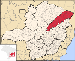
 Location of the Mesoregion of Jequitinhonha | |
| Coordinates: 16°51′00″S 42°04′12″W / 16.85000°S 42.07000°W | |
| Country | |
| Region | Southeast |
| State | |
| Area | |
| • Total | 50,143.249 km2 (19,360.417 sq mi) |
| Population (2010/IBGE) | |
| • Total | 981,121 |
| • Density | 23.8/km2 (62/sq mi) |
| Time zone | UTC-3 (BRT) |
| • Summer (DST) | UTC-2 (BRST) |
| Area code(s) | +55 33, 38 |
Vale do Jequitinhonha (English: Jequitinhonha River valley), or simply Jequitinhonha, is one of the twelve mesoregions of the Brazilian state of Minas Gerais. It is composed of 51 municipalities[1] spread across five microregions.
References
- ^ "Produto Interno Bruto dos Municípios" [GDP of the Brazilian Municipalities] (PDF) (in Portuguese). Brazilian Institute of Geography and Statistics (IBGE). 1 November 2010. Archived from the original (PDF) on 24 April 2014. Retrieved 23 December 2014.
Categories:
- Pages using gadget WikiMiniAtlas
- CS1 Portuguese-language sources (pt)
- Articles with short description
- Short description is different from Wikidata
- Coordinates on Wikidata
- Pages using infobox settlement with possible area code list
- Articles containing explicitly cited English-language text
- Articles with VIAF identifiers
- Articles with SUDOC identifiers
- Mesoregions of Minas Gerais
- All stub articles
- Minas Gerais geography stubs