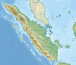
May 2010 Northern Sumatra earthquake
(Redirected from May 2010 Sumatra earthquake)
 Quake epicenter | |
| UTC time | 2010-05-09 05:59:41 |
|---|---|
| ISC event | 14686988 |
| USGS-ANSS | ComCat |
| Local date | 9 May 2010 05:59 UTC |
| Local time | 12:59 |
| Magnitude | 7.2 MW |
| Depth | 45 kilometres (28 mi) |
| Epicenter | 3°46′30″N 96°03′18″E / 3.775°N 96.055°E |
| Areas affected | Indonesia Malaysia |
| Max. intensity | MMI VII (Very strong)[1] |
| Casualties | None |
The May 2010 Northern Sumatra earthquake occurred with a moment magnitude of 7.2 on May 9 at 12:59 PM local time (5:59 UTC) in Indonesia. The epicenter was 215 km from Banda Aceh on the northwestern tip of Sumatra. According to USGS, it is likely that this earthquake occurred along the interface of the Indo-Australia Plate and the Sunda Plate. It was one of a sequence of large earthquakes along the Sunda megathrust in 2000s. It was also felt in Laos, Malaysia, Myanmar, Singapore and Thailand.[2] Broken windows and cracks in the walls were reported in the control tower at Cut Nyak Dhien Airport near Meulaboh.[3]
See also
References
- ^ National Earthquake Information Center (9 May 2010). "PAGER". United States Geological Survey. Archived from the original on 12 May 2010. Retrieved 9 April 2023.
- ^ Magnitude 7.2 - NORTHERN SUMATRA, INDONESIA
- ^ Magnitude 7.4 earthquake rattles western Indonesia
