Lithuania District
(Redirected from Lithuanian province)
| Lithuania District Verwaltungsbezirk Litauen | |||||||||||
|---|---|---|---|---|---|---|---|---|---|---|---|
| Military occupation authority of the German Empire | |||||||||||
| 1915–1918 | |||||||||||
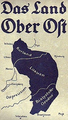
 Map of Ober Ost | |||||||||||
| Capital | Vilnius | ||||||||||
| Area | |||||||||||
| • Coordinates | 54°41′N 25°17′E / 54.683°N 25.283°E | ||||||||||
| History | |||||||||||
• Established | 1915 | ||||||||||
• Disestablished | 1918 | ||||||||||
| |||||||||||
Lithuania District (German: Verwaltungsbezirk Litauen) was an administrative division of German-controlled territory of Ober-Ost during World War I. It was bordered by the Bialystok-Grodno District to the south and the Courland District to the north.[1][2]
History
The area was formed roughly from parts of the former Vilna Governorate and Suvalki Governorate of the Russian Empire.
References
- ^ War Land on the Eastern Front: Culture, National Identity, and German Occupation in World War I, Review author[s]: Peter Gatrell
- ^ Das Land Ober Ost (in German)
Categories:
- Pages using gadget WikiMiniAtlas
- Articles with German-language sources (de)
- Coordinates on Wikidata
- States and territories established in 1915
- States and territories disestablished in 1918
- Articles containing German-language text
- German Empire in World War I
- History of Vilnius
- All stub articles
- German history stubs
- Lithuanian history stubs
- Polish history stubs
- Russian history stubs

