File:נהלל - זאב שטיין.jpg
Original file (3,992 × 2,242 pixels, file size: 11.06 MB, MIME type: image/jpeg)
This file is from a shared repository and may be used by other projects. The description on its file description page there is shown below.
Summary
Descriptionנהלל - זאב שטיין.jpg |
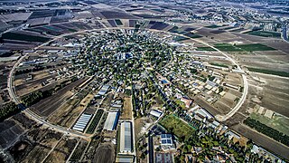
עברית: נהלל (תוכנית קאופמן)
English: Nahalal is a moshav in northern Israel. The physical layout of Nahalal, devised by architect Richard Kauffmann, became the pattern for many moshavim established before 1948; it is based on concentric circles, with the public buildings (school, administrative and offices, services, and warehouses) in the center, the homesteads in the innermost circle, the farm buildings in the next, and beyond those, ever-widening circles of gardens and fields.
|
||
Date | |||
Source | Own work | ||
Author | ZeevStein |
Camera location | 32° 41′ 33.92″ N, 35° 12′ 23.09″ E | View this and other nearby images on: OpenStreetMap | 32.692755; 35.206415 |
---|
Licensing
- You are free:
- to share – to copy, distribute and transmit the work
- to remix – to adapt the work
- Under the following conditions:
- attribution – You must give appropriate credit, provide a link to the license, and indicate if changes were made. You may do so in any reasonable manner, but not in any way that suggests the licensor endorses you or your use.
- share alike – If you remix, transform, or build upon the material, you must distribute your contributions under the same or compatible license as the original.
This image was uploaded as part of Wiki Loves Monuments 2016.
Afrikaans ∙ Alemannisch ∙ azərbaycanca ∙ Bahasa Indonesia ∙ Bahasa Melayu ∙ Bikol Central ∙ bosanski ∙ brezhoneg ∙ català ∙ čeština ∙ Cymraeg ∙ dansk ∙ davvisámegiella ∙ Deutsch ∙ eesti ∙ English ∙ español ∙ Esperanto ∙ euskara ∙ français ∙ Frysk ∙ Gaeilge ∙ galego ∙ hrvatski ∙ Ido ∙ italiano ∙ latviešu ∙ Lëtzebuergesch ∙ Malagasy ∙ magyar ∙ Malti ∙ Nederlands ∙ norsk ∙ norsk nynorsk ∙ norsk bokmål ∙ polski ∙ português ∙ português do Brasil ∙ română ∙ shqip ∙ sicilianu ∙ slovenčina ∙ slovenščina ∙ suomi ∙ svenska ∙ Tagalog ∙ Türkçe ∙ Yorùbá ∙ Zazaki ∙ Ελληνικά ∙ беларуская ∙ беларуская (тарашкевіца) ∙ български ∙ кыргызча ∙ македонски ∙ русский ∙ српски / srpski ∙ українська ∙ ქართული ∙ հայերեն ∙ नेपाली ∙ हिन्दी ∙ বাংলা ∙ മലയാളം ∙ ไทย ∙ 한국어 ∙ +/− |
|
This image has been assessed using the Quality image guidelines and is considered a Quality image.
العربية ∙ جازايرية ∙ беларуская ∙ беларуская (тарашкевіца) ∙ български ∙ বাংলা ∙ català ∙ čeština ∙ Cymraeg ∙ Deutsch ∙ Schweizer Hochdeutsch ∙ Zazaki ∙ Ελληνικά ∙ English ∙ Esperanto ∙ español ∙ eesti ∙ euskara ∙ فارسی ∙ suomi ∙ français ∙ galego ∙ עברית ∙ हिन्दी ∙ hrvatski ∙ magyar ∙ հայերեն ∙ Bahasa Indonesia ∙ italiano ∙ 日本語 ∙ Jawa ∙ ქართული ∙ 한국어 ∙ kurdî ∙ Lëtzebuergesch ∙ lietuvių ∙ македонски ∙ മലയാളം ∙ मराठी ∙ Bahasa Melayu ∙ Nederlands ∙ Norfuk / Pitkern ∙ polski ∙ português ∙ português do Brasil ∙ rumantsch ∙ română ∙ русский ∙ sicilianu ∙ slovenčina ∙ slovenščina ∙ shqip ∙ српски / srpski ∙ svenska ∙ தமிழ் ∙ తెలుగు ∙ ไทย ∙ Tagalog ∙ Türkçe ∙ toki pona ∙ українська ∙ vèneto ∙ Tiếng Việt ∙ 中文 ∙ 中文(简体) ∙ 中文(繁體) ∙ +/− |
8 October 2016
32°41'33.918"N, 35°12'23.094"E
File history
Click on a date/time to view the file as it appeared at that time.
Date/Time | Thumbnail | Dimensions | User | Comment | |
---|---|---|---|---|---|
current | 21:03, 3 November 2016 | 3,992 × 2,242 (11.06 MB) | commons>Ynhockey | User sent me a new version without the name at the bottom |
File usage
There are no pages that use this file.
Metadata
This file contains additional information, probably added from the digital camera or scanner used to create or digitize it.
If the file has been modified from its original state, some details may not fully reflect the modified file.
Camera manufacturer | DJI |
---|---|
Camera model | FC300X |
Author | Zeev Stein |
Copyright holder |
|
Exposure time | 1/1,250 sec (0.0008) |
F Number | f/2.8 |
ISO speed rating | 200 |
Date and time of data generation | 08:43, 8 October 2016 |
Lens focal length | 3.61 mm |
Latitude | 32° 41′ 33.92″ N |
Longitude | 35° 12′ 23.09″ E |
Altitude | 420.478 meters above sea level |
Label | Red |
Image title |
|
Width | 3,992 px |
Height | 2,242 px |
Bits per component |
|
Pixel composition | RGB |
Orientation | Normal |
Number of components | 3 |
Horizontal resolution | 300 dpi |
Vertical resolution | 300 dpi |
Software used | Adobe Photoshop CS6 (Windows) |
File change date and time | 22:19, 1 November 2016 |
Exposure Program | 8176 |
Exif version | 2.3 |
Date and time of digitizing | 08:43, 8 October 2016 |
APEX shutter speed | 10.287712 |
APEX aperture | 2.970854 |
APEX exposure bias | 0 |
Maximum land aperture | 2 APEX (f/2) |
Subject distance | 0 meters |
Metering mode | Center weighted average |
Light source | Unknown |
Flash | Flash did not fire, No flash function |
Color space | Uncalibrated |
File source | Digital still camera |
Scene type | A directly photographed image |
Custom image processing | Normal process |
Exposure mode | Manual exposure |
White balance | Auto white balance |
Digital zoom ratio | 0 |
Focal length in 35 mm film | 20 mm |
Scene capture type | Standard |
Scene control | None |
Contrast | Normal |
Saturation | Normal |
Sharpness | Normal |
Subject distance range | Unknown |
GPS tag version | 0.0.3.2 |
Serial number of camera | 2014031100 |
Lens used | 20.7 mm |
Rating (out of 5) | 0 |
Date metadata was last modified | 00:19, 2 November 2016 |
Unique ID of original document | B21606CCB0D771C91DE4552C574C3B70 |
IIM version | 4 |