File:Wfm usgs groom map.png
Jump to navigation
Jump to search

Size of this preview: 521 × 600 pixels. Other resolutions: 208 × 240 pixels | 417 × 480 pixels | 667 × 768 pixels | 889 × 1,024 pixels | 1,716 × 1,976 pixels.
Original file (1,716 × 1,976 pixels, file size: 4.91 MB, MIME type: image/png)
File history
Click on a date/time to view the file as it appeared at that time.
| Date/Time | Thumbnail | Dimensions | User | Comment | |
|---|---|---|---|---|---|
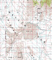
| current | 17:16, 2 April 2006 |  | 1,716 × 1,976 (4.91 MB) | commons>Finlay McWalter | {{en|Montaged segments of USGS geodetic survey map of southern Nevada, USA, showing Groom Dry Lake and surrounding area. Note that the secret Area 51 base, which satellite photographs confirm is located on the west and south shores of th lake, and its ru |
File usage
There are no pages that use this file.