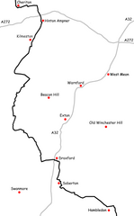
File:Wayfarers Walk Map Section 5.png
Jump to navigation
Jump to search

Size of this preview: 373 × 600 pixels. Other resolutions: 149 × 240 pixels | 298 × 480 pixels | 746 × 1,200 pixels.
Original file (746 × 1,200 pixels, file size: 85 KB, MIME type: image/png)
File history
Click on a date/time to view the file as it appeared at that time.
| Date/Time | Thumbnail | Dimensions | User | Comment | |
|---|---|---|---|---|---|
| current | 01:03, 14 March 2007 | | 746 × 1,200 (85 KB) | commons>Nick1nildram | Created by Nick Austin and released to public domain on 13th March 2007. Derived from GPS data; roads mapped by GPS between years 2000 and 2002; Trailway mapped by GPS in 2004. Uploaded for inclusion in article titled Wayfarers Walk. |
File usage
There are no pages that use this file.