File:Upper Peninsula counties map.svg
Jump to navigation
Jump to search

Size of this PNG preview of this SVG file: 615 × 584 pixels. Other resolutions: 253 × 240 pixels | 506 × 480 pixels | 809 × 768 pixels | 1,078 × 1,024 pixels | 2,157 × 2,048 pixels.
Original file (SVG file, nominally 615 × 584 pixels, file size: 1.84 MB)
Summary
| Description |
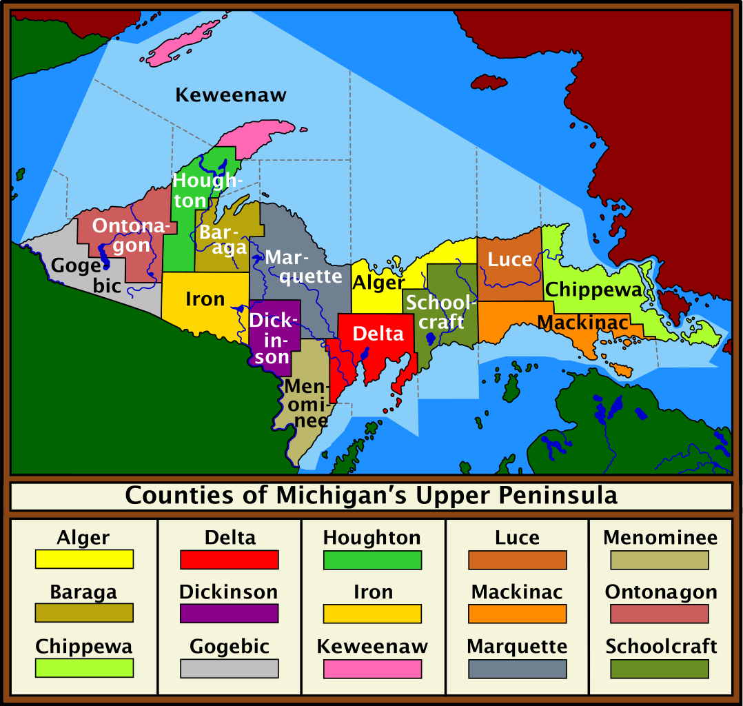
English: Color display of the counties of the Upper Peninsula of Michigan, along with color-coded key.
Sources:
Date: 04 March 2010 Author:Saukkomies |
| Date | 4 March 2010 (original upload date) |
| Source | Transferred from en.wikipedia by SreeBot |
| Author | Saukkomies at en.wikipedia |
Licensing
| This work has been released into the public domain by its author, Saukkomies at English Wikipedia. This applies worldwide. In some countries this may not be legally possible; if so: Saukkomies grants anyone the right to use this work for any purpose, without any conditions, unless such conditions are required by law. |
Original upload log
The original description page was here. All following user names refer to en.wikipedia.
Upload date | User | Bytes | Dimensions | Comment
- 2010-03-07 19:11 (UTC) | Saukkomies | 1932875 (bytes) | 615×584 | Color display of the counties of the Upper Peninsula of Michigan, along with color-coded key. <br /> <br /> Software used: InkScape Sources: <br /> <br /> * File:Michigan Locator Map.PNG <br /> * File:Michigan counties map.gif <br /> <br /> Date: 07
- 2010-03-07 18:58 (UTC) | Saukkomies | 1928363 (bytes) | 865×766 | Color display of the counties of the Upper Peninsula of Michigan, along with color-coded key. Software used: InkScape Sources: * File:Michigan Locator Map.PNG * File:Michigan counties map.gif Date: 07 March 2010 Author:[[User:Saukkomies|Saukkomies]
- 2010-03-07 00:28 (UTC) | Saukkomies | 1928014 (bytes) | 865×766 | Color display of the counties of the Upper Peninsula of Michigan, along with color-coded key. Sources: * File:Michigan Locator Map.PNG * File:Michigan counties map.gif Software used: Inkscape Date: 04 March 2010 Author:[[User:Saukkomies|Saukkomies
- 2010-03-04 16:32 (UTC) | Saukkomies | 955822 (bytes) | 865×766 | Fixing label display problem
- 2010-03-04 02:24 (UTC) | Saukkomies | 946881 (bytes) | 865×766 | Color display of the counties of the Upper Peninsula of Michigan, along with color-coded key. Sources: * File:Michigan Locator Map.PNG * File:Michigan counties map.gif Date: 04 March 2010 Author:[[Saukkomies]]
File history
Click on a date/time to view the file as it appeared at that time.
| Date/Time | Thumbnail | Dimensions | User | Comment | |
|---|---|---|---|---|---|
| current | 08:39, 13 October 2011 | | 615 × 584 (1.84 MB) | commons>SreeBot | (Original text) : Color display of the counties of the Upper Peninsula of Michigan, along with color-coded key. <br /> <br /> Software used: InkScape Sources: <br /> <br /> * File:Michigan Locator Map.PNG <br /> * File:Michigan counties map.gif <br /> |
File usage
There are no pages that use this file.