File:United States House of Representatives, South Carolina District 5 map.png
Jump to navigation
Jump to search
No higher resolution available.
United_States_House_of_Representatives,_South_Carolina_District_5_map.png (645 × 379 pixels, file size: 37 KB, MIME type: image/png)
| Description | ||||
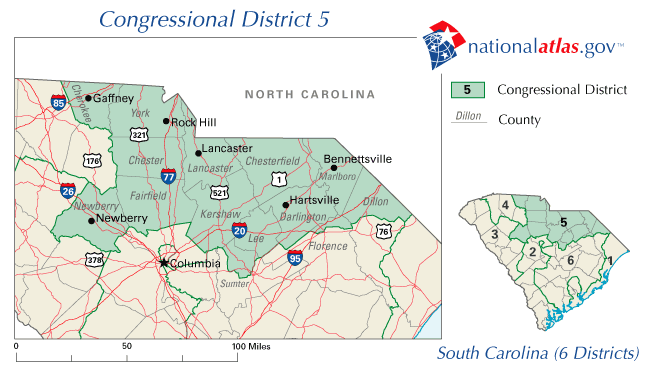
| Source | National Atlas | |||
| Author | National Atlas | |||
| Permission (Reusing this file) |
|
Original upload log
The original description page was here. All following user names refer to en.wikipedia.
- 2006-07-09 18:35 Gamecock 645×379× (37928 bytes) The map is from [http://nationalatlas.gov/printable/congress.html#sc nationalatlas.gov], specifically [http://nationalatlas.gov/printable/images/preview/congdist/SC05_109.gif SC05_109.gif].
File history
Click on a date/time to view the file as it appeared at that time.
| Date/Time | Thumbnail | Dimensions | User | Comment | |
|---|---|---|---|---|---|
| current | 15:42, 25 July 2009 | | 645 × 379 (37 KB) | commons>File Upload Bot (Magnus Manske) | {{BotMoveToCommons|en.wikipedia|year={{subst:CURRENTYEAR}}|month={{subst:CURRENTMONTHNAME}}|day={{subst:CURRENTDAY}}}} {{Information |Description={{en|The map is from [http://nationalatlas.gov/printable/congress.html#sc nationalatlas.gov], specifically [ |
File usage
There are no pages that use this file.