File:US humid subtropical.png
Jump to navigation
Jump to search

Size of this preview: 800 × 552 pixels. Other resolutions: 320 × 221 pixels | 640 × 441 pixels | 841 × 580 pixels.
Original file (841 × 580 pixels, file size: 15 KB, MIME type: image/png)
Summary
| Description |
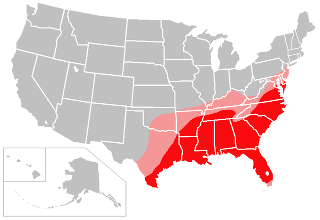
English: The red shading on this map denotes areas of the United States with a solidly humid subtropical climate; the pink shading denotes areas of the United States with a transitional/borderline humid subtropical climate.
I created this map based largely on the information contained in the Humid subtropical climate article, with supplemental information gleaned from articles about various US cities and states. Consider this to be a work in progress and feel free to suggest changes/corrections to me or make them yourself, if necessary. Points of clarification:
|
| Date | 6 January 2007 (original upload date) |
| Source | Created by user:Caliga10 |
| Author | Caliga10 at English Wikipedia |
Licensing
Caliga10 at the English-language Wikipedia, the copyright holder of this work, hereby publishes it under the following license:
| This file is licensed under the Creative Commons Attribution-Share Alike 3.0 Unported license. Subject to disclaimers. | ||
| Attribution: Caliga10 at the English-language Wikipedia | ||
| ||
| This licensing tag was added to this file as part of the GFDL licensing update. |

|
Permission is granted to copy, distribute and/or modify this document under the terms of the GNU Free Documentation License, Version 1.2 or any later version published by the Free Software Foundation; with no Invariant Sections, no Front-Cover Texts, and no Back-Cover Texts. A copy of the license is included in the section entitled GNU Free Documentation License. Subject to disclaimers. |
Original upload log
The original description page was here. All following user names refer to en.wikipedia.
- 2007-02-13 04:18 Caliga10 841×580× (15462 bytes) Updated version of this map, based on input from [[user:CrazyC83|CrazyC83]]. The following changes have been made: South Florida (except the Florida Keys) is shaded as a transitional zone (to a full tropical climate; the Keys remain unshaded since they
- 2007-01-06 23:25 Caliga10 841×580× (15505 bytes) Created by [[user:Caliga10]] I created this map based largely on the information contained in the [[Humid subtropical climate]] article, with supplemental information gleaned from articles about various US cities and states. Consider this to be a work in
File history
Click on a date/time to view the file as it appeared at that time.
| Date/Time | Thumbnail | Dimensions | User | Comment | |
|---|---|---|---|---|---|
| current | 05:56, 27 July 2013 | | 841 × 580 (15 KB) | commons>OgreBot | (BOT): Uploading old version of file from en.wikipedia; originally uploaded on 2007-02-13 04:18:41 by Caliga10 |
File usage
There are no pages that use this file.