File:US Northeastern states.svg
Jump to navigation
Jump to search

Size of this PNG preview of this SVG file: 512 × 298 pixels. Other resolutions: 320 × 186 pixels | 640 × 373 pixels | 1,024 × 596 pixels | 1,280 × 745 pixels | 2,560 × 1,490 pixels.
Original file (SVG file, nominally 512 × 298 pixels, file size: 44 KB)
Summary
| Description |
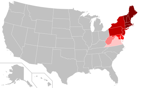
English: Map of the northeastern United States. The pink areas include states that are cited by fewer reliable sources as being included in the Northeast. The red areas are more frequently cited by reliable sources, and the dark red are the most commonly accepted as being included in the Northeast. |
| Date | |
| Source | Own work |
| Author | Pharexia |
Licensing
I, the copyright holder of this work, hereby publish it under the following license:
This file is licensed under the Creative Commons Attribution-Share Alike 4.0 International license.
- You are free:
- to share – to copy, distribute and transmit the work
- to remix – to adapt the work
- Under the following conditions:
- attribution – You must give appropriate credit, provide a link to the license, and indicate if changes were made. You may do so in any reasonable manner, but not in any way that suggests the licensor endorses you or your use.
- share alike – If you remix, transform, or build upon the material, you must distribute your contributions under the same or compatible license as the original.
File history
Click on a date/time to view the file as it appeared at that time.
| Date/Time | Thumbnail | Dimensions | User | Comment | |
|---|---|---|---|---|---|
| current | 15:20, 10 September 2018 | | 512 × 298 (44 KB) | commons>Pharexia | User created page with UploadWizard |
File usage
There are no pages that use this file.