File:US7095364 AltitudeMeasurementSystem Figure1.png
Jump to navigation
Jump to search

Size of this preview: 607 × 600 pixels. Other resolutions: 243 × 240 pixels | 486 × 480 pixels | 912 × 901 pixels.
Original file (912 × 901 pixels, file size: 90 KB, MIME type: image/png)
Summary
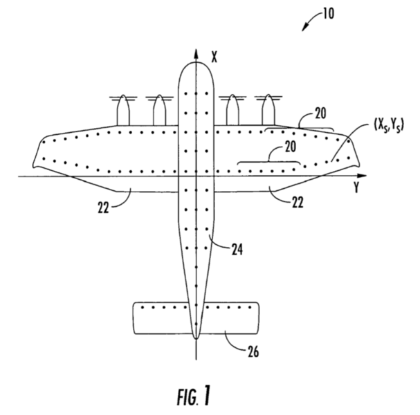
| Description | The locations of altitude measuring sensors under the fuselage and wings of the Boeing Pelican. These sensors to automatically determine how low the aircraft can fly above the water. |
| Date | |
| Source | From US patent 7095364, Rawdon, Blaine K. & Hoisington, Zachary C., "Altitude measurement system and associated methods", Figure 1, published 2005-08-04, issued 2006-08-22, assigned to The Boeing Company. |
| Author | The Boeing Company |
Licensing
This work is in the public domain in the United States because it is a work prepared by an officer or employee of the United States Government as part of that person’s official duties under the terms of Title 17, Chapter 1, Section 105 of the US Code.
Note: This only applies to original works of the Federal Government and not to the work of any individual U.S. state, territory, commonwealth, county, municipality, or any other subdivision. This template also does not apply to postage stamp designs published by the United States Postal Service since 1978. (See § 313.6(C)(1) of Compendium of U.S. Copyright Office Practices). It also does not apply to certain US coins; see The US Mint Terms of Use.
|
 | |
| This file has been identified as being free of known restrictions under copyright law, including all related and neighboring rights. | ||
File history
Click on a date/time to view the file as it appeared at that time.
| Date/Time | Thumbnail | Dimensions | User | Comment | |
|---|---|---|---|---|---|
| current | 06:48, 6 September 2018 | | 912 × 901 (90 KB) | commons>D271l | Cross-wiki upload from en.wikipedia.org |
File usage
There are no pages that use this file.