File:Tur Abdin.svg
Jump to navigation
Jump to search

Size of this PNG preview of this SVG file: 800 × 400 pixels. Other resolutions: 320 × 160 pixels | 640 × 320 pixels | 1,024 × 512 pixels | 1,280 × 640 pixels | 2,560 × 1,280 pixels | 900 × 450 pixels.
Original file (SVG file, nominally 900 × 450 pixels, file size: 318 KB)
Summary
| Camera location | | View this and other nearby images on: OpenStreetMap |
|---|
| Description |
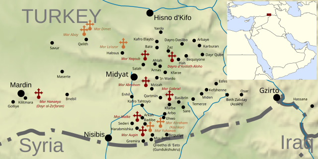
English: Map of Tur Abdin showing main villages and functioning (dark) and abandoned (light) monasteries. |
| Date | |
| Source |
|
| Author | Rafy |
| Other versions | العربيَّة |
Licensing
I, the copyright holder of this work, hereby publish it under the following license:
This file is licensed under the Creative Commons Attribution-Share Alike 3.0 Unported license.
- You are free:
- to share – to copy, distribute and transmit the work
- to remix – to adapt the work
- Under the following conditions:
- attribution – You must give appropriate credit, provide a link to the license, and indicate if changes were made. You may do so in any reasonable manner, but not in any way that suggests the licensor endorses you or your use.
- share alike – If you remix, transform, or build upon the material, you must distribute your contributions under the same or compatible license as the original.
File history
Click on a date/time to view the file as it appeared at that time.
| Date/Time | Thumbnail | Dimensions | User | Comment | |
|---|---|---|---|---|---|
| current | 14:47, 15 January 2018 | | 900 × 450 (318 KB) | commons>Protossdesign | Corrected Bequsyane to Bequsyone, didn't see that, sorry. |
File usage
There are no pages that use this file.