File:Trnovo Administrative Situation.png
Jump to navigation
Jump to search
No higher resolution available.
Trnovo_Administrative_Situation.png (396 × 285 pixels, file size: 15 KB, MIME type: image/png)
| Description |
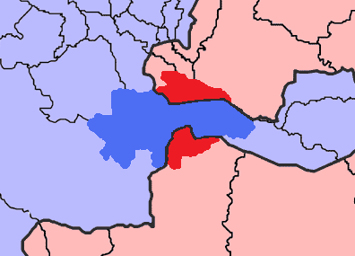
English: The map shows the two municipalities of Trnovo (FBiH) - blue and Trnovo (RS) - red, in Bosnia and Herzegovina. The Inter-Entity Boundary Line is grey.
Deutsch: Die Karte zeigt die Gemeinden Trnovo (FBiH) in blau und Trnovo (RS) in rot. Sie liegen in Bosnien und Herzegowina. Die Entitätengrenze ist grau eingezeichnet. |
| Date | |
| Source | own work based on Image:BH municipality location.gif |
| Author | j.budissin; Ante Perkovic (original map) |
| I, the copyright holder of this work, release this work into the public domain. This applies worldwide. In some countries this may not be legally possible; if so: I grant anyone the right to use this work for any purpose, without any conditions, unless such conditions are required by law. |
File history
Click on a date/time to view the file as it appeared at that time.
| Date/Time | Thumbnail | Dimensions | User | Comment | |
|---|---|---|---|---|---|
| current | 21:57, 9 November 2008 | | 396 × 285 (15 KB) | commons>J budissin | {{Information |Description= {{en|The map shows the two municipalities of Trnovo (FBiH) - blue and Trnovo (RS) - red, in Bosnia and Herzegovina. The Inter-Entity Boundary Line is grey.}} {{de|Die Karte zeigt die Gemeinden Trnovo (FBiH) in blau und Trnovo ( |
File usage
There are no pages that use this file.