File:Thakur Devi Singh Bridge East Chandra Tandi Lahaul Oct22 A7C 03356.jpg
From WikiProjectMed
Jump to navigation
Jump to search
![File:Thakur Devi Singh Bridge East Chandra Tandi Lahaul Oct22 A7C 03356.jpg](https://upload.wikimedia.org/wikipedia/commons/thumb/f/fb/Thakur_Devi_Singh_Bridge_East_Chandra_Tandi_Lahaul_Oct22_A7C_03356.jpg/400px-Thakur_Devi_Singh_Bridge_East_Chandra_Tandi_Lahaul_Oct22_A7C_03356.jpg)
Size of this preview: 400 × 600 pixels. Other resolutions: 160 × 240 pixels | 320 × 480 pixels | 512 × 768 pixels | 683 × 1,024 pixels | 1,365 × 2,048 pixels | 3,813 × 5,719 pixels.
Original file (3,813 × 5,719 pixels, file size: 14.87 MB, MIME type: image/jpeg)
This file is from a shared repository and may be used by other projects. The description on its file description page there is shown below.
Summary
DescriptionThakur Devi Singh Bridge East Chandra Tandi Lahaul Oct22 A7C 03356.jpg |
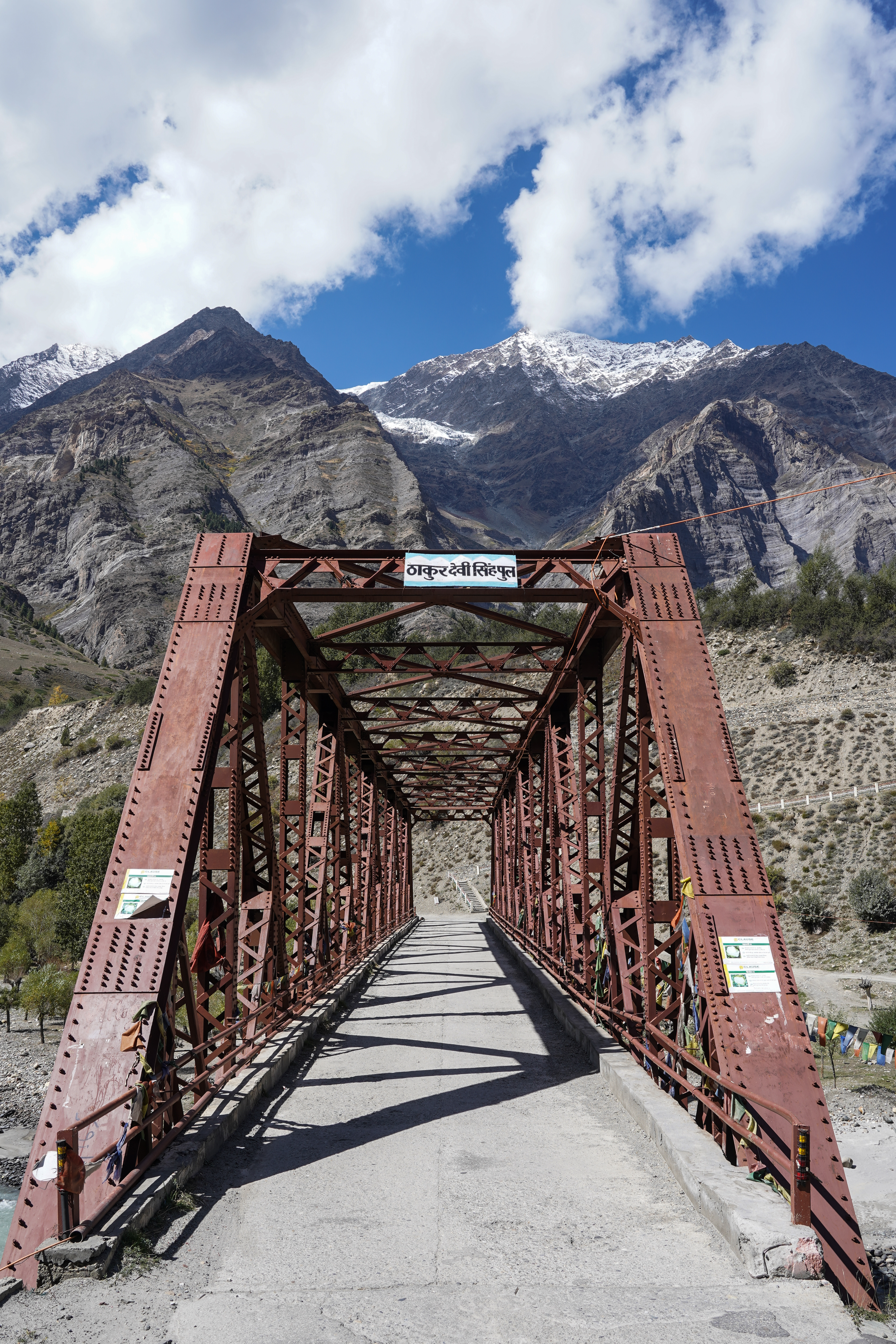
English: Thakur Devi Singh Bridge over the Chandra, view from east end, Tandi, Lahaul, Himachal, India. Elev. 2,868 m (9,409 ft) |
|||
Date | ||||
Source | Own work | |||
Author |
|
|||
Other versions |
|
Camera location | 32° 32′ 51.46″ N, 76° 58′ 31.5″ E ![]() | View this and other nearby images on: OpenStreetMap | ![]() |
---|
Assessment
|
![]() |
This image was selected as picture of the day on Vietnamese Wikipedia for 6 October 2023.
|
Licensing
I, the copyright holder of this work, hereby publish it under the following license:
![w:en:Creative Commons](https://upload.wikimedia.org/wikipedia/commons/thumb/7/79/CC_some_rights_reserved.svg/90px-CC_some_rights_reserved.svg.png)
![attribution](https://upload.wikimedia.org/wikipedia/commons/thumb/1/11/Cc-by_new_white.svg/24px-Cc-by_new_white.svg.png)
![share alike](https://upload.wikimedia.org/wikipedia/commons/thumb/d/df/Cc-sa_white.svg/24px-Cc-sa_white.svg.png)
This file is licensed under the Creative Commons Attribution-Share Alike 4.0 International license.
- You are free:
- to share – to copy, distribute and transmit the work
- to remix – to adapt the work
- Under the following conditions:
- attribution – You must give appropriate credit, provide a link to the license, and indicate if changes were made. You may do so in any reasonable manner, but not in any way that suggests the licensor endorses you or your use.
- share alike – If you remix, transform, or build upon the material, you must distribute your contributions under the same or compatible license as the original.
Captions
Thakur Devi Singh Bridge over the Chandra, view from east end, Tandi, Lahaul, Himachal. Elev. 2,868 m (9,409 ft). 2 Oct 2022
Items portrayed in this file
depicts
32°32'51.461"N, 76°58'31.505"E
0.01 second
11
31 millimetre
100
image/jpeg
File history
Click on a date/time to view the file as it appeared at that time.
Date/Time | Thumbnail | Dimensions | User | Comment | |
---|---|---|---|---|---|
current | 16:00, 13 October 2022 | ![]() | 3,813 × 5,719 (14.87 MB) | commons>Tagooty | Uploaded own work with UploadWizard |
File usage
There are no pages that use this file.
Metadata
This file contains additional information, probably added from the digital camera or scanner used to create or digitize it.
If the file has been modified from its original state, some details may not fully reflect the modified file.
Image title |
|
---|---|
Camera manufacturer | SONY |
Camera model | ILCE-7C |
Author | TA Gonsalves |
Copyright holder |
|
Exposure time | 1/100 sec (0.01) |
F Number | f/11 |
ISO speed rating | 100 |
Date and time of data generation | 11:30, 2 October 2022 |
Lens focal length | 31 mm |
Latitude | 32° 32′ 51.46″ N |
Longitude | 76° 58′ 31.51″ E |
Short title |
|
Horizontal resolution | 300 dpi |
Vertical resolution | 300 dpi |
Software used | Adobe Photoshop Lightroom 6.14 (Macintosh) |
File change date and time | 21:14, 13 October 2022 |
Exposure Program | Aperture priority |
Exif version | 2.32 |
Date and time of digitizing | 11:30, 2 October 2022 |
APEX shutter speed | 6.643856 |
APEX aperture | 6.918863 |
APEX brightness | 10.39609375 |
APEX exposure bias | 0 |
Maximum land aperture | 4.3359375 APEX (f/4.49) |
Metering mode | Pattern |
Light source | Unknown |
Flash | Flash did not fire, compulsory flash suppression |
DateTimeOriginal subseconds | 196 |
DateTimeDigitized subseconds | 196 |
Color space | sRGB |
File source | Digital still camera |
Scene type | A directly photographed image |
Custom image processing | Normal process |
Exposure mode | Auto exposure |
White balance | Auto white balance |
Digital zoom ratio | 1 |
Focal length in 35 mm film | 31 mm |
Scene capture type | Standard |
Contrast | Normal |
Saturation | Normal |
Sharpness | Normal |
GPS time (atomic clock) | 06:00 |
Receiver status | Measurement in progress |
Measurement mode | 2-dimensional measurement |
Geodetic survey data used | WGS-84 |
GPS date | 2 October 2022 |
GPS differential correction | 0 |
GPS tag version | 0.0.3.2 |
Lens used | FE 28-60mm F4-5.6 |
Date metadata was last modified | 02:44, 14 October 2022 |
Rating (out of 5) | 3 |
Unique ID of original document | A013BDBB394B884DB627AB28B7EA5E85 |
Keywords |
|
IIM version | 4 |