File:Tashkent History 1965.jpg
Jump to navigation
Jump to search

Size of this preview: 790 × 600 pixels. Other resolutions: 316 × 240 pixels | 632 × 480 pixels | 844 × 641 pixels.
Original file (844 × 641 pixels, file size: 385 KB, MIME type: image/jpeg)
Summary
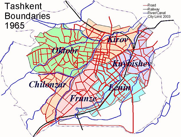
| Description | Map Of Tashkent in 1965 showing the boundaries of the city, main roads, railways and waterways (4 of 7) |
| Date | |
| Source | Self generated by author based on the Geographical Atlas of Tashkent (Ташкент Географический Атлас, Москва 1984) |
| Author | Guy Cosnahan |
Licensing
I, the copyright holder of this work, hereby publish it under the following licenses:

|
Permission is granted to copy, distribute and/or modify this document under the terms of the GNU Free Documentation License, Version 1.2 or any later version published by the Free Software Foundation; with no Invariant Sections, no Front-Cover Texts, and no Back-Cover Texts. A copy of the license is included in the section entitled GNU Free Documentation License. |
This file is licensed under the Creative Commons Attribution-Share Alike 4.0 International, 3.0 Unported, 2.5 Generic, 2.0 Generic and 1.0 Generic license.
- You are free:
- to share – to copy, distribute and transmit the work
- to remix – to adapt the work
- Under the following conditions:
- attribution – You must give appropriate credit, provide a link to the license, and indicate if changes were made. You may do so in any reasonable manner, but not in any way that suggests the licensor endorses you or your use.
- share alike – If you remix, transform, or build upon the material, you must distribute your contributions under the same or compatible license as the original.
You may select the license of your choice.
File history
Click on a date/time to view the file as it appeared at that time.
| Date/Time | Thumbnail | Dimensions | User | Comment | |
|---|---|---|---|---|---|
| current | 16:25, 7 November 2008 | | 844 × 641 (385 KB) | commons>Cosnahang~commonswiki | |Description=Map Of Tashkent in 1965 showing the boundaries of the city, main roads, railways and waterways (4 of 7) |Source=Self generated by author based on the Geographical Atlas of Tashkent (Ташкент Географический Атл |
File usage
There are no pages that use this file.