File:Tashilhunpo Thanka Wall.jpg
Jump to navigation
Jump to search

Size of this preview: 413 × 600 pixels. Other resolutions: 165 × 240 pixels | 551 × 800 pixels.
Original file (551 × 800 pixels, file size: 110 KB, MIME type: image/jpeg)
Summary
| Description |
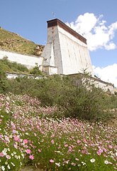
Français : Mur à thanka au monastère de Tashilhunpo, à Shigatsé, région autonome du Tibet, Chine. Des thangkas géants y sont affichés pendant la fête de l'exposition du Bouddha, du 14e au 16e jour du 5e mois du calendrier tibétain.
English: Thanka wall at Tashilhunpo monastery, Shigatse, Tibet autonomous region, China. Giant thangkhas are displayed on this wall during the Buddha Unfolding Festival, from the 14th to the 16th day of 5th month of the Tibetan calendar. |
| Date | |
| Source | Photographer: Philipp Roelli (2005) |
| Author | Dbachmann, |
| Other versions |
  |

|
Permission is granted to copy, distribute and/or modify this document under the terms of the GNU Free Documentation License, Version 1.2 or any later version published by the Free Software Foundation; with no Invariant Sections, no Front-Cover Texts, and no Back-Cover Texts. A copy of the license is included in the section entitled GNU Free Documentation License. |
| This file is licensed under the Creative Commons Attribution-Share Alike 3.0 Unported license. | ||
| ||
| This licensing tag was added to this file as part of the GFDL licensing update. |
| Object location | | View this and other nearby images on: OpenStreetMap |
|---|
File history
Click on a date/time to view the file as it appeared at that time.
| Date/Time | Thumbnail | Dimensions | User | Comment | |
|---|---|---|---|---|---|
| current | 14:24, 15 August 2016 | | 551 × 800 (110 KB) | commons>Popolon | Reverted to version as of 11:17, 29 October 2005 (UTC) |
File usage
There are no pages that use this file.