File:Stolperstein für Ernestina Metzl.jpg
![File:Stolperstein für Ernestina Metzl.jpg](https://upload.wikimedia.org/wikipedia/commons/thumb/f/f3/Stolperstein_f%C3%BCr_Ernestina_Metzl.jpg/601px-Stolperstein_f%C3%BCr_Ernestina_Metzl.jpg)
Original file (3,008 × 3,002 pixels, file size: 3.63 MB, MIME type: image/jpeg)
This file is from a shared repository and may be used by other projects. The description on its file description page there is shown below.
Summary
DescriptionStolperstein für Ernestina Metzl.jpg |
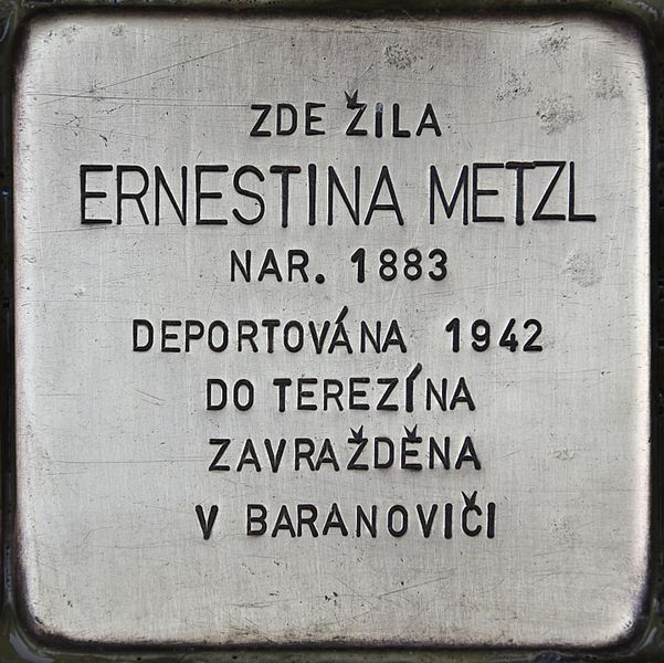
Deutsch: Stolperstein für Ernestina Metzl |
Date | |
Source | Francisco Peralta Torrejón |
Author | Francisco Peralta Torrejón |
Camera location | 50° 06′ 05.25″ N, 14° 26′ 08.99″ E ![]() | View this and other nearby images on: OpenStreetMap | ![]() |
---|
Licensing
This template covers the upload of photographies of Stolpersteine, monuments, commemorative plaques and memorial stones by Francisco Peralta Torrejón. An extra permission may be required if there are works of other authors visible in these photos. The use of this template is limited to Donna Gedenk and volunteer response team members only.
![]() ![]() ![]() This file is licensed under the Creative Commons Attribution-Share Alike 4.0 International license. Attribution: Francisco Peralta Torrejón
|
Captions
Items portrayed in this file
depicts
21 January 2017
50°6'5.249"N, 14°26'8.988"E
File history
Click on a date/time to view the file as it appeared at that time.
Date/Time | Thumbnail | Dimensions | User | Comment | |
---|---|---|---|---|---|
current | 20:41, 24 February 2017 | ![]() | 3,008 × 3,002 (3.63 MB) | commons>Donna Gedenk | User created page with UploadWizard |
File usage
There are no pages that use this file.
Metadata
This file contains additional information, probably added from the digital camera or scanner used to create or digitize it.
If the file has been modified from its original state, some details may not fully reflect the modified file.
Camera manufacturer | NIKON CORPORATION |
---|---|
Camera model | NIKON D750 |
Exposure time | 1/250 sec (0.004) |
F Number | f/5.6 |
ISO speed rating | 400 |
Date and time of data generation | 10:33, 21 January 2017 |
Lens focal length | 300 mm |
Latitude | 50° 6′ 5.25″ N |
Longitude | 14° 26′ 8.99″ E |
Altitude | 197 meters above sea level |
Orientation | Normal |
Horizontal resolution | 300 dpi |
Vertical resolution | 300 dpi |
Software used | Ver.1.00 |
File change date and time | 14:27, 24 February 2017 |
Y and C positioning | Co-sited |
Exposure Program | Not defined |
Exif version | 2.3 |
Date and time of digitizing | 10:33, 21 January 2017 |
Meaning of each component |
|
Image compression mode | 4 |
APEX exposure bias | 0 |
Maximum land aperture | 5 APEX (f/5.66) |
Metering mode | Pattern |
Light source | Unknown |
Flash | Flash did not fire, compulsory flash suppression |
DateTime subseconds | 79 |
DateTimeOriginal subseconds | 79 |
DateTimeDigitized subseconds | 79 |
Supported Flashpix version | 1 |
Color space | sRGB |
Sensing method | One-chip color area sensor |
File source | Digital still camera |
Scene type | A directly photographed image |
Custom image processing | Normal process |
Exposure mode | Auto exposure |
White balance | Auto white balance |
Digital zoom ratio | 1 |
Focal length in 35 mm film | 300 mm |
Scene capture type | Standard |
Scene control | Low gain up |
Contrast | Normal |
Saturation | Normal |
Sharpness | Normal |
Subject distance range | Unknown |
Unique image ID | 488E58BDD5094485A7D7465CE79A509D |
GPS time (atomic clock) | 09:33 |
Satellites used for measurement | 08 |
GPS date | 21 January 2017 |
GPS tag version | 2.3.0.0 |