File:Smaalensbanen map 1884.jpg

Original file (614 × 1,028 pixels, file size: 944 KB, MIME type: image/jpeg)
| Description |
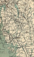
Norsk bokmål: Kart over Smaalensbanen. |
||||
| Date | |||||
| Source | Kart over Smaalenenes, Akershus, Jarlsberg og Laurvigs Amter, samt Dele af Bratsberg, Budskerud m.m. | ||||
| Author | Det private Opmaalings Kontor. | ||||
| Permission (Reusing this file) |
|
||||
File history
Click on a date/time to view the file as it appeared at that time.
| Date/Time | Thumbnail | Dimensions | User | Comment | |
|---|---|---|---|---|---|
| current | 19:18, 3 April 2008 | | 614 × 1,028 (944 KB) | commons>Mahlum | {{Information |Description={{no|Kart over Smaalensbanen.}} |Source=''Kart over Smaalenenes, Akershus, Jarlsberg og Laurvigs Amter, samt Dele af Bratsberg, Budskerud m.m.'' |Date=1884 |Author=Det private Opmaalings Kontor. |Permission={{PD-old}} |other_ver |
File usage
There are no pages that use this file.