File:Site of the Burris House at Lockport.jpg
Jump to navigation
Jump to search

Size of this preview: 800 × 600 pixels. Other resolutions: 320 × 240 pixels | 640 × 480 pixels | 1,024 × 768 pixels | 1,280 × 960 pixels | 2,560 × 1,920 pixels | 2,816 × 2,112 pixels.
Original file (2,816 × 2,112 pixels, file size: 3.53 MB, MIME type: image/jpeg)
|
This is an image of a place or building that is listed on the National Register of Historic Places in the United States of America. Its reference number is 77000018. |
| Camera location | | View this and other nearby images on: OpenStreetMap |
|---|
| Description |
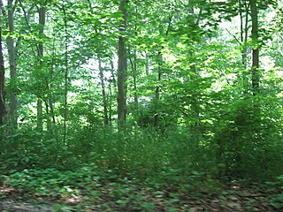
English: Site of the Burris House, located along Towpath Road at Lockport in Adams Township, Carroll County, Indiana, United States. Built in 1838 and since destroyed, the house and the nearby Potawatomi Spring are listed together on the National Register of Historic Places. |
||
| Date | Taken on 4 June 2011 | ||
| Source | Own work | ||
| Author | Nyttend | ||
| Permission (Reusing this file) |
|
File history
Click on a date/time to view the file as it appeared at that time.
| Date/Time | Thumbnail | Dimensions | User | Comment | |
|---|---|---|---|---|---|
| current | 03:54, 9 June 2011 | | 2,816 × 2,112 (3.53 MB) | commons>Nyttend | {{Location|40|42|56|N|86|34|27|W}} {{Information |Description={{en|Site of the {{w|Burris House and Potawatomi Spring|Burris House}}, located along Towpath Road at {{w|Lockport, Indiana|Lockport}} in {{w|Adams Township, Carroll County, Indiana|Adams Towns |
File usage
There are no pages that use this file.