File:Sint Maarten-CIA WFB Map.png
Jump to navigation
Jump to search
No higher resolution available.
Sint_Maarten-CIA_WFB_Map.png (330 × 353 pixels, file size: 14 KB, MIME type: image/png)
File history
Click on a date/time to view the file as it appeared at that time.
| Date/Time | Thumbnail | Dimensions | User | Comment | |
|---|---|---|---|---|---|
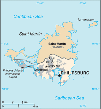
| current | 11:32, 23 October 2010 | | 330 × 353 (14 KB) | commons>Hoshie | {{Information |Description= Map of {{w|Sint Maarten}} from the 2010-10-22 revision of the World Factbook |Source= [https://www.cia.gov/library/publications/the-world-factbook/maps/maptemplate_sk.html World Factbook website] |Date= 2010-10-22 |Author= Dire |
File usage
There are no pages that use this file.