File:SimonCanP.jpg
Jump to navigation
Jump to search

Size of this preview: 471 × 599 pixels. Other resolutions: 189 × 240 pixels | 377 × 480 pixels | 604 × 768 pixels | 805 × 1,024 pixels | 1,610 × 2,048 pixels | 4,044 × 5,144 pixels.
Original file (4,044 × 5,144 pixels, file size: 4.26 MB, MIME type: image/jpeg)
| Description |
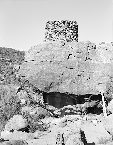
English: Simon Canyon Pueblito, Approximately 0.6 mile north of Simon Canyon confluence with San Juan River, Blanco vicinity, San Juan County, NM. |
|||||
| Date | after 1933 | |||||
| Source | Library of Congress, Prints and Photograph Division HABS: NM,23-BLAN.V,2-5 | |||||
| Author | Thallheimer, Arnold , photographer | |||||
| Permission (Reusing this file) |
|

| Camera location | | View this and other nearby images on: OpenStreetMap |
|---|
Original upload log
The original description page was here. All following user names refer to en.wikipedia.
- 2008-03-26 02:07 Tillman 826×1024× (168094 bytes) TITLE: Simon Canyon Pueblito, Approximately 0.6 mile north of Simon Canyon confluence with San Juan River, Blanco vicinity, San Juan County, NM CALL NUMBER: HABS NM,23-BLAN.V,2- http://memory.loc.gov/pnp/habshaer/nm/nm0100/nm0161/photos/381271pv.jpg
File history
Click on a date/time to view the file as it appeared at that time.
| Date/Time | Thumbnail | Dimensions | User | Comment | |
|---|---|---|---|---|---|
| current | 01:09, 29 March 2013 | | 4,044 × 5,144 (4.26 MB) | commons>Ras67 | cropped and leveled high resolution version from LOC |
File usage
There are no pages that use this file.