File:ScarboroughPopGraph.jpg
Jump to navigation
Jump to search

Size of this preview: 682 × 599 pixels. Other resolutions: 273 × 240 pixels | 546 × 480 pixels | 774 × 680 pixels.
Original file (774 × 680 pixels, file size: 80 KB, MIME type: image/jpeg)
Summary
| Description |
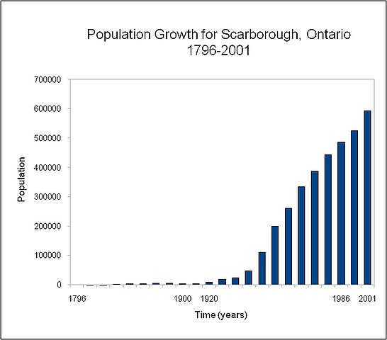
English: Graph of population growth for Scarborough, Ontario, from 1796-2001. |
| Date | |
| Source | Own work |
| Author | Photoist |
Census data for Scarborough after 2001 is difficult to gauge as the data for southeast Scarborough is taken from a riding that now includes part of Pickering.
Licensing
I, the copyright holder of this work, hereby publish it under the following license:
This file is licensed under the Creative Commons Attribution 3.0 Unported license.
- You are free:
- to share – to copy, distribute and transmit the work
- to remix – to adapt the work
- Under the following conditions:
- attribution – You must give appropriate credit, provide a link to the license, and indicate if changes were made. You may do so in any reasonable manner, but not in any way that suggests the licensor endorses you or your use.
File history
Click on a date/time to view the file as it appeared at that time.
| Date/Time | Thumbnail | Dimensions | User | Comment | |
|---|---|---|---|---|---|
| current | 15:39, 9 November 2008 | | 774 × 680 (80 KB) | commons>Photoist | {{Information |Description={{en|1=Graph of population growth for Scarborough, Ontario, from 1796-2001. }} |Source=Own work by uploader |Author=Photoist |Date=November 9, 2008 |Permission= |other_versions= }} Census data for Scarborou |
File usage
There are no pages that use this file.