File:Reka-Timavo karta.jpg
Jump to navigation
Jump to search

Size of this preview: 800 × 568 pixels. Other resolutions: 320 × 227 pixels | 640 × 454 pixels | 1,024 × 727 pixels | 1,106 × 785 pixels.
Original file (1,106 × 785 pixels, file size: 102 KB, MIME type: image/jpeg)
Summary
| Description |
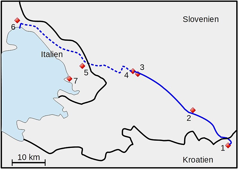
Svenska: Ungefärlig karta över Reka-Timavo. Streckad linje visar flodens underjordiska sträckning (efter Alexander, Paul B.: The Reka-Timavo River System of the Yugoslavian and Italian Karst. Yearbook of the Association of Pacific Coast Geographers Vol. 32 (1970), p. 159).
1=Vela Voda (flod). 2=Ilirska Bistrica. 3=Vremski Britof. 4=Škocjan. 5=Trebiciano. 6=Monfalcone. 7=Trieste |
| Date | |
| Source | Own work |
| Author | Leksunim |
Licensing
I, the copyright holder of this work, hereby publish it under the following license:
This file is licensed under the Creative Commons Attribution-Share Alike 4.0 International license.
- You are free:
- to share – to copy, distribute and transmit the work
- to remix – to adapt the work
- Under the following conditions:
- attribution – You must give appropriate credit, provide a link to the license, and indicate if changes were made. You may do so in any reasonable manner, but not in any way that suggests the licensor endorses you or your use.
- share alike – If you remix, transform, or build upon the material, you must distribute your contributions under the same or compatible license as the original.
File history
Click on a date/time to view the file as it appeared at that time.
| Date/Time | Thumbnail | Dimensions | User | Comment | |
|---|---|---|---|---|---|
| current | 09:23, 10 September 2019 | | 1,106 × 785 (102 KB) | commons>Leksunim | User created page with UploadWizard |
File usage
There are no pages that use this file.