File:Railway map of France - Lyon - animated - fr.gif
Jump to navigation
Jump to search

Size of this preview: 800 × 562 pixels. Other resolutions: 320 × 225 pixels | 640 × 449 pixels | 1,024 × 719 pixels | 1,280 × 898 pixels | 2,016 × 1,415 pixels.
Original file (2,016 × 1,415 pixels, file size: 26.83 MB, MIME type: image/gif, looped, 33 frames, 35 s)
Note: Due to technical limitations, thumbnails of high resolution GIF images such as this one will not be animated.
File history
Click on a date/time to view the file as it appeared at that time.
| Date/Time | Thumbnail | Dimensions | User | Comment | |
|---|---|---|---|---|---|
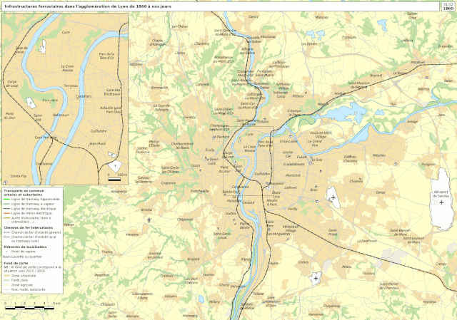
| current | 14:37, 26 May 2022 | | 2,016 × 1,415 (26.83 MB) | commons>Benjism89 | {{Information |Description= {{fr|Évolution historique du réseau ferroviaire dans l'agglomération de Lyon (69). Voir ci-dessous pour une description détaillée, les sources et les autres versions de cette carte.}} {{en|Railway evolution map of French city of Lyon (69), in French. See below from detailed description, sources and other versions.}} |Source={{own}} |Date=2022-05-26 |Author= Benjamin Smith {{fr|Le fond de carte utilise des données issues des bases Geofla 2016, E... |
File usage
There are no pages that use this file.