File:ROC vs PRC.svg
Jump to navigation
Jump to search

Size of this PNG preview of this SVG file: 800 × 548 pixels. Other resolutions: 320 × 219 pixels | 640 × 439 pixels | 1,024 × 702 pixels | 1,280 × 878 pixels | 2,560 × 1,755 pixels | 1,339 × 918 pixels.
Original file (SVG file, nominally 1,339 × 918 pixels, file size: 1.71 MB)
Summary
| Description |
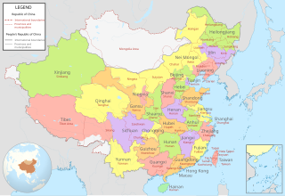
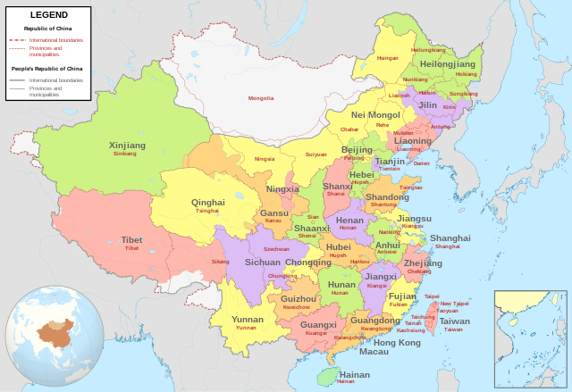
English: Comparison between Republic of China (1953-2002 in Taiwan) and People's Republic of China administrative divisions.
Adapted from File:ROC PRC comparison eng.jpg. The original ROC map included more cities, but the adaptation removed non-central municipalities to clean up the image. Therefore, this image contains: Republic of China
People's Republic of China
|
| Date | |
| Source |
Own work based on: China (+claims, +Hainan), administrative divisions - Blank - colored.svg |
| Author | Milenioscuro |
,_administrative_divisions_-_Blank_-_colored.svg)
Licensing
I, the copyright holder of this work, hereby publish it under the following license:
This file is licensed under the Creative Commons Attribution-Share Alike 4.0 International license.
- You are free:
- to share – to copy, distribute and transmit the work
- to remix – to adapt the work
- Under the following conditions:
- attribution – You must give appropriate credit, provide a link to the license, and indicate if changes were made. You may do so in any reasonable manner, but not in any way that suggests the licensor endorses you or your use.
- share alike – If you remix, transform, or build upon the material, you must distribute your contributions under the same or compatible license as the original.
- ↑ “Taiwan Veto Likely; Taipei Regime May Again Bar Outer Mongolia From U.N.”, in The New York Times[1], 22 April 1961
- ↑ 中華民國年鑑. Archived from the original on April 19, 2003. Retrieved on January 21, 2017.
File history
Click on a date/time to view the file as it appeared at that time.
| Date/Time | Thumbnail | Dimensions | User | Comment | |
|---|---|---|---|---|---|
| current | 05:04, 15 July 2022 | | 1,339 × 918 (1.71 MB) | commons>Tjs2012 | Adjust borders |
File usage
There are no pages that use this file.