File:Photograph of Federal Records Center, Alexandria, Virginia (34877725360).jpg

Original file (3,841 × 3,033 pixels, file size: 3.05 MB, MIME type: image/jpeg)
.jpg)
Summary
| Description |
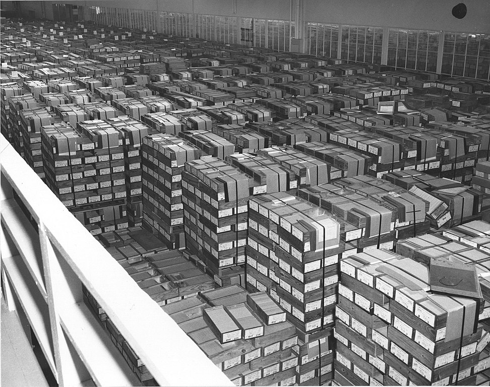
Creator(s): General Services Administration. National Archives and Records Service. Office of Educational Programs. Education Division. ?-4/1/1985 Series: Historic Photograph File of National Archives Events and Personnel, 1935 - 1975 Record Group 64: Records of the National Archives and Records Administration, 1789 - ca. 2007921 Production Date: 11/4/1959 Access Restriction(s):Unrestricted Use Restriction(s):Unrestricted Contact(s): National Archives at College Park - Still Pictures (RDSS) National Archives at College Park 8601 Adelphi Road College Park, MD 20740-6001 Phone: 301-837-0561 Fax: 301-837-3621 Email: stillpix@nara.gov National Archives Identifier: 12169529 Local Identifier: 64-NA-1715 Persistent URL: catalog.archives.gov/id/12169529 "Storage of IBM record cards at the Federal records center in Alexandria, Virginia, November 1959. Between 1950 and 1966 the records centers received millions of cubic feet of records, saving the federal government more than the total spent for the entire operation of the National Archives Records Service." Note: There are about 20 rows of pallets visible, each row is 15 pallets wide, pallets are stacked two high (at least). Each pallet contains 45 boxes of punched cards. Standard card boxes contained 2000 cards. Each card held up to 80 characters, for a total of about 4.3 billion characters of data in this storage facility - about the same as a 4GB flash drive. |
| Date | |
| Source | Photograph of Federal Records Center, Alexandria, Virginia |
| Author | The U.S. National Archives |
| Permission (Reusing this file) |
The U.S. National Archives @ Flickr Commons |
| Camera location | | View this and other nearby images on: OpenStreetMap |
|---|
.jpg¶ms=038.797729_N_-077.055252_E_globe:Earth_type:camera_source:Flickr_&language=en)
Licensing
This image was taken from Flickr's The Commons. The uploading organization may have various reasons for determining that no known copyright restrictions exist, such as:
More information can be found at https://flickr.com/commons/usage/. Please add additional copyright tags to this image if more specific information about copyright status can be determined. See Commons:Licensing for more information. |
| This image was originally posted to Flickr by The U.S. National Archives at https://flickr.com/photos/35740357@N03/34877725360 (archive). It was reviewed on 11 January 2018 by FlickreviewR 2 and was confirmed to be licensed under the terms of the No known copyright restrictions. |
This work is in the public domain in the United States because it is a work prepared by an officer or employee of the United States Government as part of that person’s official duties under the terms of Title 17, Chapter 1, Section 105 of the US Code.
Note: This only applies to original works of the Federal Government and not to the work of any individual U.S. state, territory, commonwealth, county, municipality, or any other subdivision. This template also does not apply to postage stamp designs published by the United States Postal Service since 1978. (See § 313.6(C)(1) of Compendium of U.S. Copyright Office Practices). It also does not apply to certain US coins; see The US Mint Terms of Use.
|
 | |
| This file has been identified as being free of known restrictions under copyright law, including all related and neighboring rights. | ||
File history
Click on a date/time to view the file as it appeared at that time.
| Date/Time | Thumbnail | Dimensions | User | Comment | |
|---|---|---|---|---|---|
| current | 17:59, 11 January 2018 | | 3,841 × 3,033 (3.05 MB) | commons>Artix Kreiger 2 | Transferred from Flickr via Flickr2Commons |
File usage
There are no pages that use this file.
.jpg)