File:Perth Railway map.svg
Jump to navigation
Jump to search

Size of this PNG preview of this SVG file: 799 × 169 pixels. Other resolutions: 320 × 68 pixels | 640 × 135 pixels | 1,024 × 217 pixels | 1,280 × 271 pixels | 2,560 × 542 pixels | 2,694 × 570 pixels.
Original file (SVG file, nominally 2,694 × 570 pixels, file size: 74 KB)
File history
Click on a date/time to view the file as it appeared at that time.
| Date/Time | Thumbnail | Dimensions | User | Comment | |
|---|---|---|---|---|---|
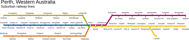
| current | 13:00, 16 March 2008 | 2,694 × 570 (74 KB) | commons>Moondyne | {{Information |Description={{en|A diagram of the suburban railway lines in en:Perth, Western Australia, including the Mandurah Railway Line (opening late 2007/early 2008).}} |Source=Transferred from [http://en.wikipedia.org en.wikipedia] |Date=2007-0 |
File usage
There are no pages that use this file.