File:Panama Canal Map EN.png
Jump to navigation
Jump to search

Size of this preview: 581 × 600 pixels. Other resolutions: 232 × 240 pixels | 465 × 480 pixels | 744 × 768 pixels | 992 × 1,024 pixels | 2,191 × 2,262 pixels.
Original file (2,191 × 2,262 pixels, file size: 3.48 MB, MIME type: image/png)
Summary
| Description |
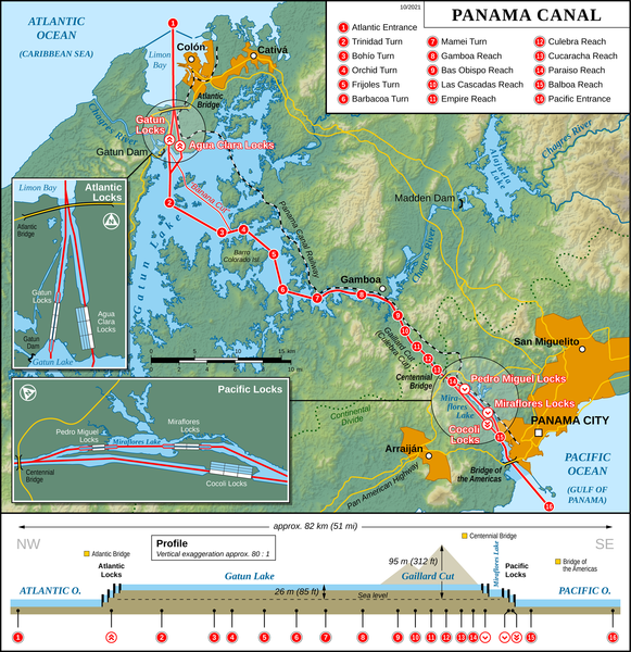
English: Map of the Panama Canal (English version)
Deutsch: Karte des Panamakanals (Englische Version) |
| Date | |
| Source |
Own work Map created using: |
| Author | Thoroe |
| Permission (Reusing this file) |
Map data (c) OpenStreetMap (and) contributors, CC-BY-SA |
| Other versions |
[]
|


|
This map has been made or improved in the German Kartenwerkstatt (Map Lab). You can propose maps to improve as well.
|

|
File:Panama Canal Map EN.svg is a vector version of this file. It should be used in place of this PNG file when not inferior.
File:Panama Canal Map EN.png → File:Panama Canal Map EN.svg
For more information, see Help:SVG. |
 |
Licensing
This file is licensed under the Creative Commons Attribution-Share Alike 2.0 Generic license.
Attribution: Thomas Römer/OpenStreetMap data
- You are free:
- to share – to copy, distribute and transmit the work
- to remix – to adapt the work
- Under the following conditions:
- attribution – You must give appropriate credit, provide a link to the license, and indicate if changes were made. You may do so in any reasonable manner, but not in any way that suggests the licensor endorses you or your use.
- share alike – If you remix, transform, or build upon the material, you must distribute your contributions under the same or compatible license as the original.
File history
Click on a date/time to view the file as it appeared at that time.
| Date/Time | Thumbnail | Dimensions | User | Comment | |
|---|---|---|---|---|---|
| current | 15:49, 3 October 2021 | | 2,191 × 2,262 (3.48 MB) | commons>Thoroe | + Atlantic Bridge |
File usage
There are no pages that use this file.