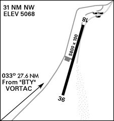
File:Pahute-Mesa-Airport-Diagram.png
Jump to navigation
Jump to search

Size of this preview: 565 × 600 pixels. Other resolutions: 226 × 240 pixels | 452 × 480 pixels | 1,021 × 1,084 pixels.
Original file (1,021 × 1,084 pixels, file size: 22 KB, MIME type: image/png)
File history
Click on a date/time to view the file as it appeared at that time.
| Date/Time | Thumbnail | Dimensions | User | Comment | |
|---|---|---|---|---|---|
| current | 14:32, 1 September 2021 | | 1,021 × 1,084 (22 KB) | commons>Recoil16 | Uploaded a work by National Geospatial-Intelligence Agency from [https://www.cnatra.navy.mil/tw4/vt27/assets/docs/flight-planning/USVFR-SUP.pdf DoD Flight Information Publication (Enroute) - VFR Supplement United States] with UploadWizard |
File usage
There are no pages that use this file.