File:POL powiat białostocki map.svg
Jump to navigation
Jump to search

Size of this PNG preview of this SVG file: 408 × 599 pixels. Other resolutions: 163 × 240 pixels | 327 × 480 pixels | 523 × 768 pixels | 697 × 1,024 pixels | 1,394 × 2,048 pixels | 750 × 1,102 pixels.
Original file (SVG file, nominally 750 × 1,102 pixels, file size: 57 KB)
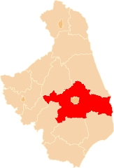
| Description | Położenie powiatu białostockiego na mapie województwa podlaskiego |
| Date | |
| Source | Own work |
| Author | Poznaniak |
| Permission (Reusing this file) |
This file is licensed under the Creative Commons Attribution-Share Alike 2.5 Generic license.
|
File history
Click on a date/time to view the file as it appeared at that time.
| Date/Time | Thumbnail | Dimensions | User | Comment | |
|---|---|---|---|---|---|
| current | 17:39, 23 March 2009 | | 750 × 1,102 (57 KB) | commons>Poznaniak | {{Information |Description=Położenie powiatu białostockiego na mapie województwa podlaskiego |Source=własna praca |Date=23.03.2009 |Author=Poznaniak |Permission={{cc-by-sa-2.5}} }} [[Category:Locator ma |
File usage
There are no pages that use this file.