File:Ordnance Survey One-Inch Sheet 132 Coventry and Rugby, Published 1946 (Cov-Nun crop).jpg
Jump to navigation
Jump to search

Size of this preview: 278 × 599 pixels. Other resolutions: 111 × 240 pixels | 222 × 480 pixels | 356 × 768 pixels | 475 × 1,024 pixels | 1,500 × 3,234 pixels.
Original file (1,500 × 3,234 pixels, file size: 5.36 MB, MIME type: image/jpeg)
.jpg)
File history
Click on a date/time to view the file as it appeared at that time.
| Date/Time | Thumbnail | Dimensions | User | Comment | |
|---|---|---|---|---|---|
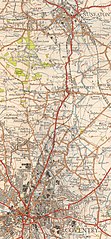
| current | 20:45, 24 March 2022 | | 1,500 × 3,234 (5.36 MB) | commons>G-13114 | {{Information |description={{en|1=OS map of Coventry Rugby and the surrounding region in Warwickshire Northamptonshire and Leicestershire, at a scale of 1:63,360 or one inch to one mile.}} |date=1946-12-31 |source=Scan of original OS map |author=Director General of the Ordnance Survey, UK |permission= |other versions= cropped from File:Ordnance_Survey_One-Inch_Sheet_132_Coventry_and_Rugby,_Published_1946.jpg }} =={{int:license-header}}== {{oldOS}} [[Category:Ordnance Survey New Popula... |
File usage
There are no pages that use this file.
.jpg)