File:North atlantic map - saint pierre and miquelon.png
Jump to navigation
Jump to search

Size of this preview: 800 × 585 pixels. Other resolutions: 320 × 234 pixels | 640 × 468 pixels | 1,024 × 749 pixels | 1,267 × 927 pixels.
Original file (1,267 × 927 pixels, file size: 384 KB, MIME type: image/png)
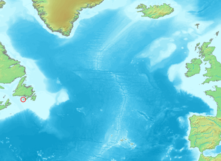
- Position of Saint Pierre and Miquelon in the North Atlantic
- After a screenshot from: http://www.demis.nl
This image is in the public domain because it came from the site https://www.demis.nl/products/web-map-server/examples/ and was released by the copyright holder. Permission is granted to copy, distribute and/or modify this map since it is based on free of copyright images from: www.demis.nl. See also approval email on de.wp and its clarification.
|
| This work has been released into the public domain by its copyright holder, www.demis.nl. This applies worldwide. In some countries this may not be legally possible; if so: www.demis.nl grants anyone the right to use this work for any purpose, without any conditions, unless such conditions are required by law.
|
File history
Click on a date/time to view the file as it appeared at that time.
| Date/Time | Thumbnail | Dimensions | User | Comment | |
|---|---|---|---|---|---|
| current | 17:20, 23 May 2005 | | 1,267 × 927 (384 KB) | commons>Arne List | *Position of Saint Pierre and Miquelon in the North Atlantic *After a screenshot from: http://www.demis.nl {{PD}} |
File usage
There are no pages that use this file.