File:National map of eastern provinces of German Reich based on official census of 1910.jpg
Jump to navigation
Jump to search

Size of this preview: 779 × 600 pixels. Other resolutions: 312 × 240 pixels | 624 × 480 pixels | 998 × 768 pixels | 1,280 × 986 pixels | 2,560 × 1,971 pixels | 17,595 × 13,547 pixels.
Original file (17,595 × 13,547 pixels, file size: 34.26 MB, MIME type: image/jpeg)
File history
Click on a date/time to view the file as it appeared at that time.
| Date/Time | Thumbnail | Dimensions | User | Comment | |
|---|---|---|---|---|---|
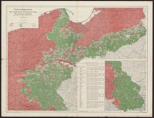
| current | 15:38, 3 November 2013 | | 17,595 × 13,547 (34.26 MB) | commons>Jackmcbarn | {{Information | description = National map of eastern provinces of German Reich based on official census of 1910 ({{lang-de|Nationalitätenkarte der östlichen Provinzen des Deutschen Reiches nach dem Ergebnissen der amtlichen Volkszählung vom Jahre 1... |
File usage
There are no pages that use this file.