File:Mount Kenya Population map-en.svg
Jump to navigation
Jump to search

Size of this PNG preview of this SVG file: 387 × 600 pixels. Other resolutions: 155 × 240 pixels | 310 × 480 pixels | 495 × 768 pixels | 660 × 1,024 pixels | 1,321 × 2,048 pixels | 1,802 × 2,793 pixels.
Original file (SVG file, nominally 1,802 × 2,793 pixels, file size: 1.18 MB)
File history
Click on a date/time to view the file as it appeared at that time.
| Date/Time | Thumbnail | Dimensions | User | Comment | |
|---|---|---|---|---|---|
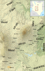
| current | 05:58, 3 March 2010 | | 1,802 × 2,793 (1.18 MB) | commons>Erp | {{Information |Description={{en|Map of the population around Mount Kenya, in french.}} {{fr|Carte des peuples habitant la région du Mont Kenya.}} |Source=*File:Mount_Kenya_Population_map-fr.svg |Date=2010-03-0 |
File usage
There are no pages that use this file.