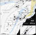
File:Morphometry of Concepcion Bank. Evidence of Geological and Biological Processes on a Large Volcanic Seamount of the Canary Islands Seamount Province. 2016 Rivera et al. Fig. 1.PNG
Jump to navigation
Jump to search

Size of this preview: 627 × 599 pixels. Other resolutions: 251 × 240 pixels | 502 × 480 pixels | 804 × 768 pixels | 1,072 × 1,024 pixels | 2,207 × 2,109 pixels.
Original file (2,207 × 2,109 pixels, file size: 1.37 MB, MIME type: image/png)
File history
Click on a date/time to view the file as it appeared at that time.
| Date/Time | Thumbnail | Dimensions | User | Comment | |
|---|---|---|---|---|---|
| current | 05:37, 14 April 2018 |  | 2,207 × 2,109 (1.37 MB) | commons>Asqueladd | == {{int:filedesc}} == {{Information |description={{en|1='''Fig 1. General bathymetric map of the Canary Islands Seamount Province (CISP).'''<br /><br />Note the seamounts, islands and other relevant physiographic features as well as the regional surface current system. The Canary Basin, the Canary Ridge, the Canary Channel and its diapir belt extending northwards are indicated. Numbers attached to seamounts and islands represent individual oldest age estimate where available, after Van den B... |
File usage
There are no pages that use this file.