File:Mississippi delta from space.jpg
Jump to navigation
Jump to search

Size of this preview: 564 × 599 pixels. Other resolutions: 226 × 240 pixels | 452 × 480 pixels | 723 × 768 pixels | 963 × 1,024 pixels | 1,797 × 1,910 pixels.
Original file (1,797 × 1,910 pixels, file size: 794 KB, MIME type: image/jpeg)
Summary
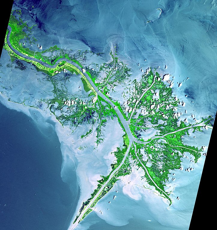
| Description | Mississippi River Delta from space. This image was acquired on May 24, 2001 by the Advanced Spaceborne Thermal Emission and Reflection Radiometer (ASTER) on NASA's Terra satellite. Hurricanes Katrina and Rita destroyed much of the Mississippi River Delta in 2005. |
| Date | |
| Source |
http://photojournal.jpl.nasa.gov/catalog/PIA03497
|
| Author | NASA |
This image or video was catalogued by Jet Propulsion Laboratory of the United States National Aeronautics and Space Administration (NASA) under Photo ID: PIA03497. This tag does not indicate the copyright status of the attached work. A normal copyright tag is still required. See Commons:Licensing. Other languages:
|
Licensing
| This file is in the public domain in the United States because it was solely created by NASA. NASA copyright policy states that "NASA material is not protected by copyright unless noted". (See Template:PD-USGov, NASA copyright policy page or JPL Image Use Policy.) | ||
 |
Warnings:
|
File history
Click on a date/time to view the file as it appeared at that time.
| Date/Time | Thumbnail | Dimensions | User | Comment | |
|---|---|---|---|---|---|
| current | 22:06, 12 March 2007 | | 1,797 × 1,910 (794 KB) | commons>Interiot~commonswiki | little bigger version (not the full 4MB version, but a 50% x 50% version of largest), since mediawiki will scale as needed |
File usage
There are no pages that use this file.