File:Mexico east tehuantepec states.png
Jump to navigation
Jump to search

Size of this preview: 800 × 553 pixels. Other resolutions: 320 × 221 pixels | 640 × 443 pixels | 943 × 652 pixels.
Original file (943 × 652 pixels, file size: 91 KB, MIME type: image/png)
File history
Click on a date/time to view the file as it appeared at that time.
| Date/Time | Thumbnail | Dimensions | User | Comment | |
|---|---|---|---|---|---|
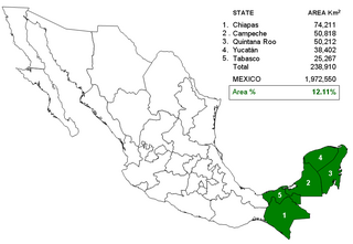
| current | 05:38, 28 September 2006 | | 943 × 652 (91 KB) | commons>AlexCovarrubias | Map of Mexico highlighting the 5 states (Campeche, Chiapas, Quintana Roo, Tabasco and Yucatán) east of the Isthmus of Tehuantepec sometimes considered within Central America by some geographers. Statistics of state area and re |
File usage
There are no pages that use this file.