File:Mar Balear delineada.jpg
Jump to navigation
Jump to search

Size of this preview: 643 × 600 pixels. Other resolutions: 257 × 240 pixels | 514 × 480 pixels | 823 × 768 pixels | 1,060 × 989 pixels.
Original file (1,060 × 989 pixels, file size: 203 KB, MIME type: image/jpeg)
Summary
| Description |
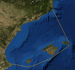
Català: Foto satèl·lit de la Mar Balear, delineada
Español: Foto satelital del Mar Balear
English: Satellite Picture of the Balearic Sea, delineated |
|||
| Date | ||||
| Source | Satellite picture from NASA World Wind Globe, version 1.4; lines my work, based on definition at Limits of Oceans and Seas, 3rd edition by International Hydrographic Organisation. | |||
| Author | NASA, Rwxrwxrwx | |||
| Permission (Reusing this file) |
|

File history
Click on a date/time to view the file as it appeared at that time.
| Date/Time | Thumbnail | Dimensions | User | Comment | |
|---|---|---|---|---|---|
| current | 20:50, 30 September 2014 | | 1,060 × 989 (203 KB) | commons>Rwxrwxrwx | User created page with UploadWizard |
File usage
There are no pages that use this file.