File:Map of the phylogeographic structure of Hydrobates markhami.png
Jump to navigation
Jump to search

Size of this preview: 800 × 354 pixels. Other resolutions: 320 × 142 pixels | 640 × 283 pixels | 1,024 × 453 pixels | 1,280 × 567 pixels | 3,200 × 1,417 pixels.
Original file (3,200 × 1,417 pixels, file size: 1.15 MB, MIME type: image/png)
File history
Click on a date/time to view the file as it appeared at that time.
| Date/Time | Thumbnail | Dimensions | User | Comment | |
|---|---|---|---|---|---|
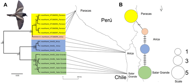
| current | 21:46, 6 December 2023 | | 3,200 × 1,417 (1.15 MB) | commons>FunkMonk | {{Information |Description=Map of the phylogeographic structure of Hydrobates markhami. Map of the phylogeographic structure of Hydrobates markhami showing: (A) the mtDNA ND1 Bayesian Inference (BI) and Maximum Likelihood (ML) phylogeny and the distribution of the three main clades (upper node values represent BI posterior probabilities and down nodes values represent ML bootstrap values). (B) Haplotype network and each locality; the scale represents the sample size for each locality. At the... |
File usage
There are no pages that use this file.