File:Map of the Kars-Akhalkalaki-Tbilisi-Baku railway.png
Jump to navigation
Jump to search

Size of this preview: 800 × 494 pixels. Other resolutions: 320 × 198 pixels | 640 × 395 pixels | 1,024 × 633 pixels | 1,280 × 791 pixels | 1,742 × 1,076 pixels.
Original file (1,742 × 1,076 pixels, file size: 2.34 MB, MIME type: image/png)
| Description |
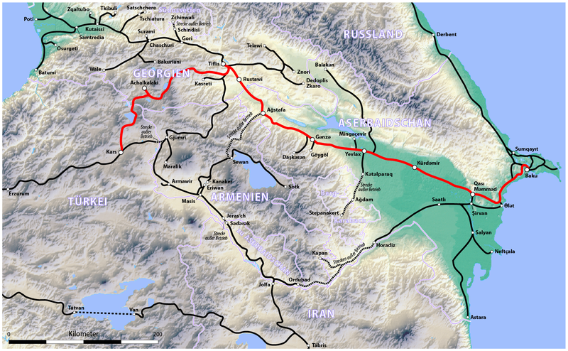
Deutsch: Karte der Bahnstrecke Kars–Achalkalaki–Tiflis–Baku (KATB)
English: Map of the Kars-Akhalkalaki-Tbilisi-Baku railway (KATB) |
||||||||||
| Date | see file history | ||||||||||
| Source |
own work, using the following files:
|
||||||||||
| Author | Maximilian Dörrbecker (Chumwa) | ||||||||||
| Permission (Reusing this file) |
I, the copyright holder of this work, hereby publish it under the following license: This file is licensed under the Creative Commons Attribution-Share Alike 2.5 Generic license.
|

File history
Click on a date/time to view the file as it appeared at that time.
| Date/Time | Thumbnail | Dimensions | User | Comment | |
|---|---|---|---|---|---|
| current | 06:02, 31 October 2017 | | 1,742 × 1,076 (2.34 MB) | commons>Chumwa |
File usage
There are no pages that use this file.