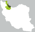
File:Map of Talysh-inhabited provinces of Iran, according to a poll in 2011.png
Jump to navigation
Jump to search

Size of this preview: 652 × 600 pixels. Other resolutions: 261 × 240 pixels | 522 × 480 pixels.
Original file (800 × 736 pixels, file size: 33 KB, MIME type: image/png)
File history
Click on a date/time to view the file as it appeared at that time.
| Date/Time | Thumbnail | Dimensions | User | Comment | |
|---|---|---|---|---|---|
| current | 17:01, 20 December 2020 |  | 800 × 736 (33 KB) | commons>Matreeks | Corrected according to the survey carried out by Ministry of Culture of İran for Ardabil and Zanjan Provinces. Here e.g. https://commons.wikimedia.org/wiki/File:Map_of_Turkic-inhabited_provinces_of_Iran,_according_to_a_poll_in_2008.png we see Ardabil province has 98.2% Azerbaijani language speakers, according to the same source, how Talish language can be spoken by 8.2%?! The sum will be more thsn 100%! |
File usage
There are no pages that use this file.