File:Map of Serbia (Vojvodina).PNG
Jump to navigation
Jump to search

Size of this preview: 426 × 599 pixels. Other resolutions: 171 × 240 pixels | 341 × 480 pixels | 976 × 1,372 pixels.
Original file (976 × 1,372 pixels, file size: 692 KB, MIME type: image/png)
.PNG)

|
This locator map image could be re-created using vector graphics as an SVG file. This has several advantages; see Commons:Media for cleanup for more information. If an SVG form of this image is available, please upload it and afterwards replace this template with
{{vector version available|new image name}}.
It is recommended to name the SVG file “Map of Serbia (Vojvodina).svg”—then the template Vector version available (or Vva) does not need the new image name parameter. |
| Description |
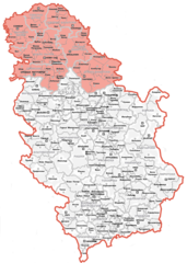
English: map showing location of Vojvodina within Serbia
Српски / srpski: мапа која приказује положај Војводине у Србији |
||
| Date | |||
| Source | Image:Map of Serbia (municipalities).PNG | ||
| Author | Bože pravde | ||
| Permission (Reusing this file) |
|
.PNG)
File history
Click on a date/time to view the file as it appeared at that time.
| Date/Time | Thumbnail | Dimensions | User | Comment | |
|---|---|---|---|---|---|
| current | 16:14, 19 November 2022 | | 976 × 1,372 (692 KB) | commons>Yann | Reverted to version as of 11:59, 13 November 2022 (UTC) |
File usage
There are no pages that use this file.
.PNG)