File:Map of Pompeii in Roman Campania.png
Jump to navigation
Jump to search
No higher resolution available.
Map_of_Pompeii_in_Roman_Campania.png (400 × 260 pixels, file size: 60 KB, MIME type: image/png)
File history
Click on a date/time to view the file as it appeared at that time.
| Date/Time | Thumbnail | Dimensions | User | Comment | |
|---|---|---|---|---|---|
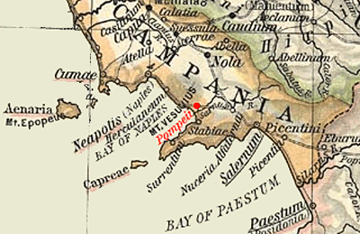
| current | 19:50, 16 November 2005 | | 400 × 260 (60 KB) | commons>Marcus Cyron | == Summary == Map of Campania during the Roman period, highlighting Pompeii. Extracted and adapted from ''The Historical Atlas'' by William R. Shepherd, 1911. Original image is at http://www.lib.utexas.edu/maps/historical/shephe |
File usage
There are no pages that use this file.