File:Map of Land Ceded by Treaty of Fort Jackson.png
Jump to navigation
Jump to search
No higher resolution available.
Map_of_Land_Ceded_by_Treaty_of_Fort_Jackson.png (320 × 336 pixels, file size: 25 KB, MIME type: image/png)
File history
Click on a date/time to view the file as it appeared at that time.
| Date/Time | Thumbnail | Dimensions | User | Comment | |
|---|---|---|---|---|---|
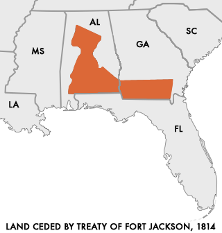
| current | 14:48, 28 March 2006 | | 320 × 336 (25 KB) | commons>Cień | {{Information| |Description=Map of Land Ceded to the United States by the warring Creek Nations in the Treaty of Fort Jackson of 1814. I created this map using as reference a map "Creek Land Cessions Map 1733 through 1832" from the Horseshoe Bend |
File usage
There are no pages that use this file.