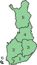
File:Map of Finland with provinces (numbered).png
Jump to navigation
Jump to search
No higher resolution available.
Map_of_Finland_with_provinces_(numbered).png (150 × 260 pixels, file size: 2 KB, MIME type: image/png)
.png)
File history
Click on a date/time to view the file as it appeared at that time.
| Date/Time | Thumbnail | Dimensions | User | Comment | |
|---|---|---|---|---|---|
| current | 15:37, 12 October 2007 | | 150 × 260 (2 KB) | commons>Skies | Map of Finland with the Province lines visible (numbered) (c) adrian.benko, 2005, based on images by (c) helix84, 2005, based on images by (c) Jani Niemenmaa, 2003 {{GFDL}} [[Category:Locator m |
File usage
There are no pages that use this file.
.png)