File:Map Gaels Brythons Picts.png
Jump to navigation
Jump to search

Size of this preview: 465 × 600 pixels. Other resolutions: 186 × 240 pixels | 372 × 480 pixels | 643 × 829 pixels.
Original file (643 × 829 pixels, file size: 66 KB, MIME type: image/png)
File history
Click on a date/time to view the file as it appeared at that time.
| Date/Time | Thumbnail | Dimensions | User | Comment | |
|---|---|---|---|---|---|
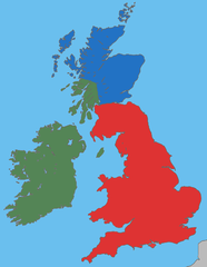
| current | 04:37, 27 March 2009 | | 643 × 829 (66 KB) | commons>Asarlaí | {{Information |Description={{en|1=A map showing the approximate areas where the Gaelic (green), Brythonic (red) and Pictish (blue) languages were spoken around 450-500 CE.}} |Source=Own work, based on [http://commons.wikimedia.org/wiki/File:Uk_map_home_na |
File usage
There are no pages that use this file.