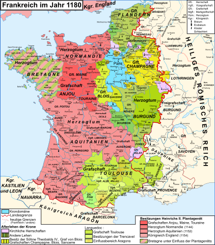
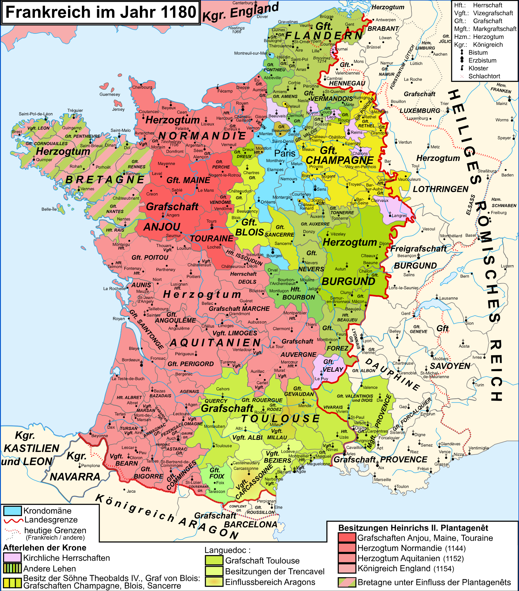
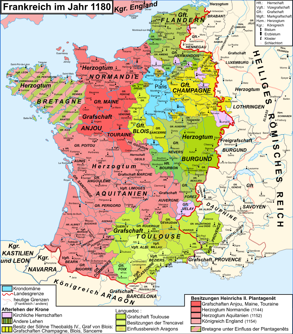
File:Map France 1180-de.svg
Jump to navigation
Jump to search

Size of this PNG preview of this SVG file: 527 × 600 pixels. Other resolutions: 211 × 240 pixels | 422 × 480 pixels | 675 × 768 pixels | 900 × 1,024 pixels | 1,800 × 2,048 pixels | 988 × 1,124 pixels.
Original file (SVG file, nominally 988 × 1,124 pixels, file size: 1.94 MB)
Summary
| Description |
Deutsch: Karte Frankreichs im Jahr 1180
Français : Carte de la France en 1180
English: Map of France in 1180 |
||
| Date | (UTC) | ||
| Source | Map France 1180-fr.svg | ||
| Author |
Quellen/Sources:
|
||
| Other versions |
|
||
| SVG development | This map was created with Adobe Illustrator.
|

Legende
Licensing
I, the copyright holder of this work, hereby publish it under the following licenses:
This file is licensed under the Creative Commons Attribution-Share Alike 3.0 Unported, 2.5 Generic, 2.0 Generic and 1.0 Generic license.
- You are free:
- to share – to copy, distribute and transmit the work
- to remix – to adapt the work
- Under the following conditions:
- attribution – You must give appropriate credit, provide a link to the license, and indicate if changes were made. You may do so in any reasonable manner, but not in any way that suggests the licensor endorses you or your use.
- share alike – If you remix, transform, or build upon the material, you must distribute your contributions under the same or compatible license as the original.

|
Permission is granted to copy, distribute and/or modify this document under the terms of the GNU Free Documentation License, Version 1.2 or any later version published by the Free Software Foundation; with no Invariant Sections, no Front-Cover Texts, and no Back-Cover Texts. A copy of the license is included in the section entitled GNU Free Documentation License. |
You may select the license of your choice.
Original upload log
This image is a derivative work of the following images:
- File:Map France 1180-fr.svg licensed with Cc-by-sa-3.0,2.5,2.0,1.0, GFDL
- 2009-01-09T11:35:35Z Zigeuner 988x1124 (1972311 Bytes) + seigneurie de Montpensier, couleur du Velay, vicomté de Marsan
- 2008-12-12T15:51:47Z Zigeuner 988x1124 (1970361 Bytes) Retour des limites d'arrière-fiefs dans le duché d'Aquitaine
- 2008-12-12T14:07:15Z Zigeuner 988x1124 (1970370 Bytes) + comté d'Alençon, seigneurie d'Harcourt (Normandie)
- 2008-12-06T15:42:18Z Zigeuner 988x1124 (1967888 Bytes) Tonnerre de la même couleur que Nevers et Auxerre
- 2008-12-05T22:43:51Z Zigeuner 988x1124 (1967902 Bytes) Couleurs identiques pour Flandres/Vermandois/Valois
- 2008-12-03T15:02:56Z Zigeuner 988x1124 (1966588 Bytes) {{Information |Description={{en|1=Map of the France in 1180}} {{fr|1=Carte de la France en 1180}} |Source=travail personnel (own work) |Author=[[User:Zigeuner|Zigeuner]] |Date=3 XII 2008 |Permission= |other_versions=Image:Map
Uploaded with derivativeFX
File history
Click on a date/time to view the file as it appeared at that time.
| Date/Time | Thumbnail | Dimensions | User | Comment | |
|---|---|---|---|---|---|
| current | 22:50, 21 May 2020 | | 988 × 1,124 (1.94 MB) | commons>Furfur | Herzogtümer -> Grafschaften, Farben etwas adaptiert |
File usage
There are no pages that use this file.