File:Manhattan Topo Land Use 1865 below Fourteenth Street (LCN g3804n.ct002003).png
Jump to navigation
Jump to search

Size of this preview: 491 × 600 pixels. Other resolutions: 196 × 240 pixels | 393 × 480 pixels | 629 × 768 pixels | 838 × 1,024 pixels | 2,500 × 3,053 pixels.
Original file (2,500 × 3,053 pixels, file size: 14.89 MB, MIME type: image/png)
Summary
| Description |
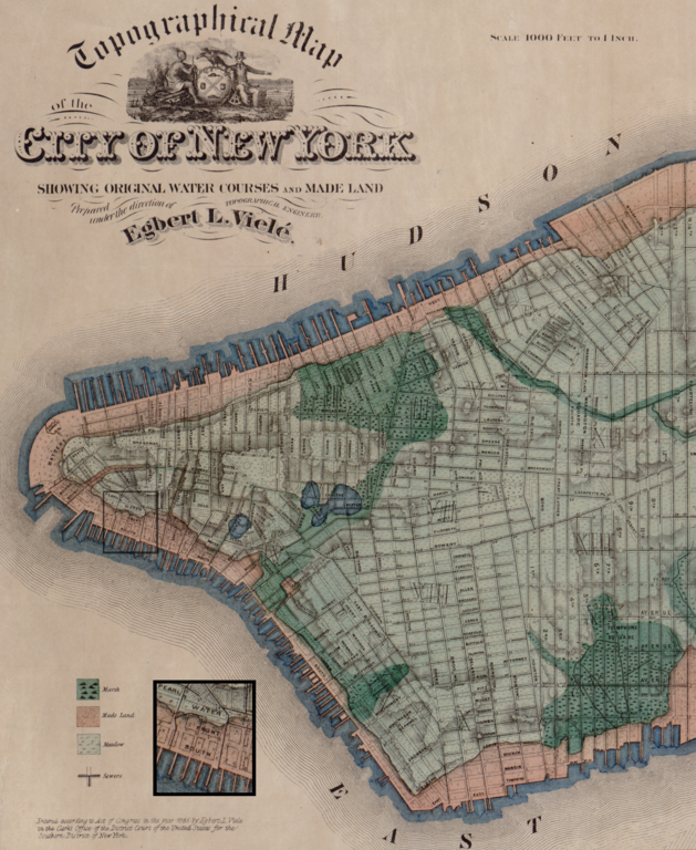
English: Map of Manhattan in 1865 with topographic features showing original water courses and made land in area of Water, Front and South streets.
From Topographical map of the City of New York : showing original water courses and made land LCCN 2006629795 |
|||||||||
| Date | ||||||||||
| Source | Topographical map of the City of New York : showing original water courses and made land from LOC g3804n.ct002003 | |||||||||
| Creator |
Viele, Egbert L. (Egbert Ludovicus), 1825-1902. Ferd. Mayer & Co. |
|||||||||
| Geotemporal data | ||||||||||
| Bounding box |
|
|||||||||
| Georeferencing | ||||||||||
| Other versions |
|
|||||||||
.png)
.png)
.png)

|
This map is available from the United States Library of Congress's Geography & Map Division
under the digital ID g3804n.ct002003. This tag does not indicate the copyright status of the attached work. A normal copyright tag is still required. See Commons:Licensing.
|
Licensing
|
This work is in the public domain in its country of origin and other countries and areas where the copyright term is the author's life plus 70 years or fewer. This work is in the public domain in the United States because it was published (or registered with the U.S. Copyright Office) before January 1, 1929. | |
| This file has been identified as being free of known restrictions under copyright law, including all related and neighboring rights. | |
File history
Click on a date/time to view the file as it appeared at that time.
| Date/Time | Thumbnail | Dimensions | User | Comment | |
|---|---|---|---|---|---|
| current | 11:57, 28 January 2022 | | 2,500 × 3,053 (14.89 MB) | commons>DutchTreat | Uploaded a work by Viele, Egbert L. (Egbert Ludovicus), 1825-1902. Ferd. Mayer & Co. from Topographical map of the City of New York : showing original water courses and made land from LOC [http://hdl.loc.gov/loc.gmd/g3804n.ct002003 g3804n.ct002003] with UploadWizard |
File usage
There are no pages that use this file.
.png)