File:Macquarie Island Map Mawson.png
Jump to navigation
Jump to search

Size of this preview: 453 × 600 pixels. Other resolutions: 181 × 240 pixels | 620 × 821 pixels.
Original file (620 × 821 pixels, file size: 468 KB, MIME type: image/png)
Summary
| Description |
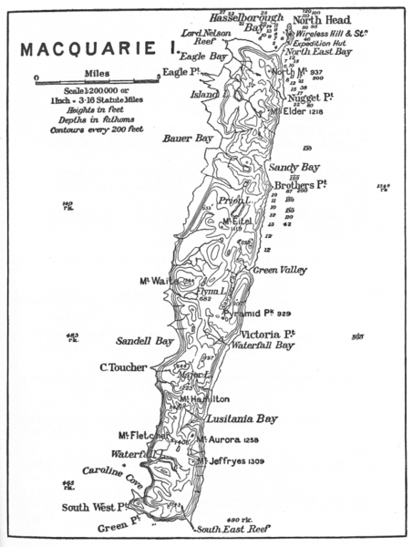
English: Map of Macquarie Island produced by the Australasian Antarctic Expedition of 1911–1914 |
| Date | |
| Source | Mawson, D. (1914). The Home of the Blizzard. |
| Author | Australasian Antarctic Expedition of 1911–1914 |
Licensing
This image or other work is of Australian origin and is now in the public domain because its term of copyright has expired. According to the Australian Copyright Council (ACC), ACC Information Sheet G023v19 (Duration of copyright) (January 2019).1
When using this template, please provide information of where the image was first published and who created it. |
 | |||||||||||||||||||
This work is in the public domain in the United States because it was published (or registered with the U.S. Copyright Office) before January 1, 1929.
|
This image or other work is of Australian origin and is now in the public domain because its term of copyright has expired. According to the Australian Copyright Council (ACC), ACC Information Sheet G023v19 (Duration of copyright) (January 2019).1
When using this template, please provide information of where the image was first published and who created it. |
| |||||||||||||||||||
First published in Mawson, D. (1914). The Home of the Blizzard.
File history
Click on a date/time to view the file as it appeared at that time.
| Date/Time | Thumbnail | Dimensions | User | Comment | |
|---|---|---|---|---|---|
| current | 00:01, 15 February 2020 | | 620 × 821 (468 KB) | commons>Yomangani | User created page with UploadWizard |
File usage
There are no pages that use this file.